
Magnitude |
:3.8 |
| Date & Time (UTC) | 2014-01-25 09:14:35.2 |
| Date & Time (Local) | 1392/11/5 12:44:35.2 |
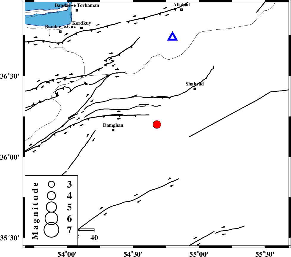
| Location | Lat:36.2 Lon: 54.68 |
| Region | Semnan Province, 30 km East of Damghan |
Nearest Cities |
|
| 11 km East of Mehmandust, Semnan Province | |
| 30 km North East of Damghan, Semnan Province | |
| 31 km South of Majen, Semnan Province | |
| 34 km South West of Ruyan, Semnan Province | |
| 36 km South West of Shahrud, Semnan Province | |
| Depth | 7 km |
| Agency | |
Faults within 150 km: |
|
| ATARI_F (Length: 185 km) , Distance to epicenter: 7 km | |
| DAMGHAN_F (Length: 95 km) , Distance to epicenter: 13 km | |
| MEYAMEY_F (Length: 141 km) , Distance to epicenter: 24 km | |
| Number of Phases | 8 |
| RMS | 0.1 |
| Number of Stations | 8 |
| Error in Latitude | >2.6 km |
| Error in Longitude | 2.3 km |
| Error in Depth | 4.5 km |
Download waveform in seisan format
to download seisan software Click here
to access information about IIEES stations Click here
Amplitude | ||||||||
| UID | Agency | Station | Component | Amplitude | Period | Arrival Time | Proccessing Time | Signal Clip |
| 91601 | IIEES | GHVR | E | 204.3 | 0.33 | 2014-01-25 09:16:34 | 2014-01-25 09:49:00 | n |
Phase | ||||||||||||
| Agency | Station | Component | Phase Type | Phase Quality | First Motion | Observed Arrival Time | Time Residual | Loc. Flag | Input Weight | Distance | Azimuth | |
| IIEES | SHRO | E | Pg | E | 2014-01-25 09:14:56 | 0 | y | 122 | 100 | |||
| IIEES | BJRD | Z | Pn | E | 2014-01-25 09:15:20 | -0.05 | y | 294 | 55 | |||
| IIEES | CHTH | Z | Pn | E | 2014-01-25 09:15:23 | 0.02 | y | 322 | 265 | |||
| IIEES | TABS | Z | Pn | E | 2014-01-25 09:15:28 | 0.17 | y | 361 | 141 | |||
| IIEES | GHVR | Z | Pn | E | 2014-01-25 09:15:29 | 0.05 | y | 366 | 239 | |||
| IIEES | YZKH | Z | Pn | E | 2014-01-25 09:15:36 | -0.22 | y | 423 | 181 | |||
| IIEES | KHMZ | Z | Pn | E | 2014-01-25 09:15:47 | 0.01 | y | 510 | 239 | |||
| IIEES | ZNJK | Z | E | 2014-01-25 09:15:50 | y | 540 | 277 | |||||