
Magnitude |
:4.2 |
| Date & Time (UTC) | 2014-01-22 03:32:07.5 |
| Date & Time (Local) | 1392/11/2 07:02:07.5 |
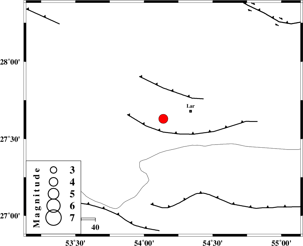
| Location | Lat:27.63 Lon: 54.14 |
| Region | Fars Province, 21 km West of Lar |
Nearest Cities |
|
| 3 km of Grash, Fars Province | |
| 18 km North East of Bagh, Fars Province | |
| 19 km South East of Avaz, Fars Province | |
| 20 km West of Lar, Fars Province | |
| 25 km West of Latifi, Fars Province | |
| Depth | 15 km |
| Agency | |
Faults within 150 km: |
|
| LAR_F (Length: 99 km) , Distance to epicenter: 10 km | |
| BERIZ_F (Length: 49 km) , Distance to epicenter: 22 km | |
| MFF1 (Length: 180 km) , Distance to epicenter: 59 km | |
| Number of Phases | 8 |
| RMS | 0.3 |
| Number of Stations | 9 |
| Error in Latitude | >5.3 km |
| Error in Longitude | 2 km |
| Error in Depth | 0 km |
Download waveform in seisan format
to download seisan software Click here
to access information about IIEES stations Click here
Amplitude | ||||||||
| UID | Agency | Station | Component | Amplitude | Period | Arrival Time | Proccessing Time | Signal Clip |
| 91573 | IIEES | AHRM | E | 442.9 | 0.3 | 2014-01-22 03:34:09 | 2014-01-22 05:24:00 | n |
| 91574 | IIEES | AHRM | N | 583 | 0.44 | 2014-01-22 03:34:16 | 2014-01-22 05:24:00 | n |
| 91575 | IIEES | CHBR | E | 76.7 | 0.36 | 2014-01-22 03:35:17 | 2014-01-22 05:24:00 | n |
| 91576 | IIEES | CHBR | N | 59.2 | 0.3 | 2014-01-22 03:35:17 | 2014-01-22 05:24:00 | n |
| 91577 | IIEES | SHGR | E | 101.6 | 0.47 | 2014-01-22 03:35:27 | 2014-01-22 05:24:00 | n |
| 91578 | IIEES | SHGR | N | 78.2 | 0.51 | 2014-01-22 03:35:30 | 2014-01-22 05:24:00 | n |
Phase | ||||||||||||
| Agency | Station | Component | Phase Type | Phase Quality | First Motion | Observed Arrival Time | Time Residual | Loc. Flag | Input Weight | Distance | Azimuth | |
| IIEES | AHRM | Z | Pn | E | 2014-01-22 03:32:53 | 0.02 | y | 310 | 297 | |||
| IIEES | YZKH | Z | Pn | E | 2014-01-22 03:33:21 | 0.23 | y | 529 | 5 | |||
| IIEES | CHBR | Z | Pn | E | 2014-01-22 03:33:38 | 0.29 | y | 671 | 108 | |||
| IIEES | ZHSF | Z | Pn | E | 2014-01-22 03:33:39 | -0.59 | y | 685 | 70 | |||
| IIEES | TABS | Z | Pn | E | 2014-01-22 03:33:45 | 0.27 | y | 726 | 22 | |||
| IIEES | KHMZ | Z | Pn | E | 2014-01-22 03:33:52 | -0.18 | y | 786 | 330 | |||
| IIEES | GHVR | Z | Pn | E | 2014-01-22 03:33:55 | 0.02 | y | 808 | 341 | |||
| IIEES | SNGE | Z | Pn | E | 2014-01-22 03:34:25 | -0.53 | y | 1049 | 324 | |||