
Magnitude |
:3.3 |
| Date & Time (UTC) | 2014-01-13 19:34:21.8 |
| Date & Time (Local) | 1392/10/23 23:04:21.8 |
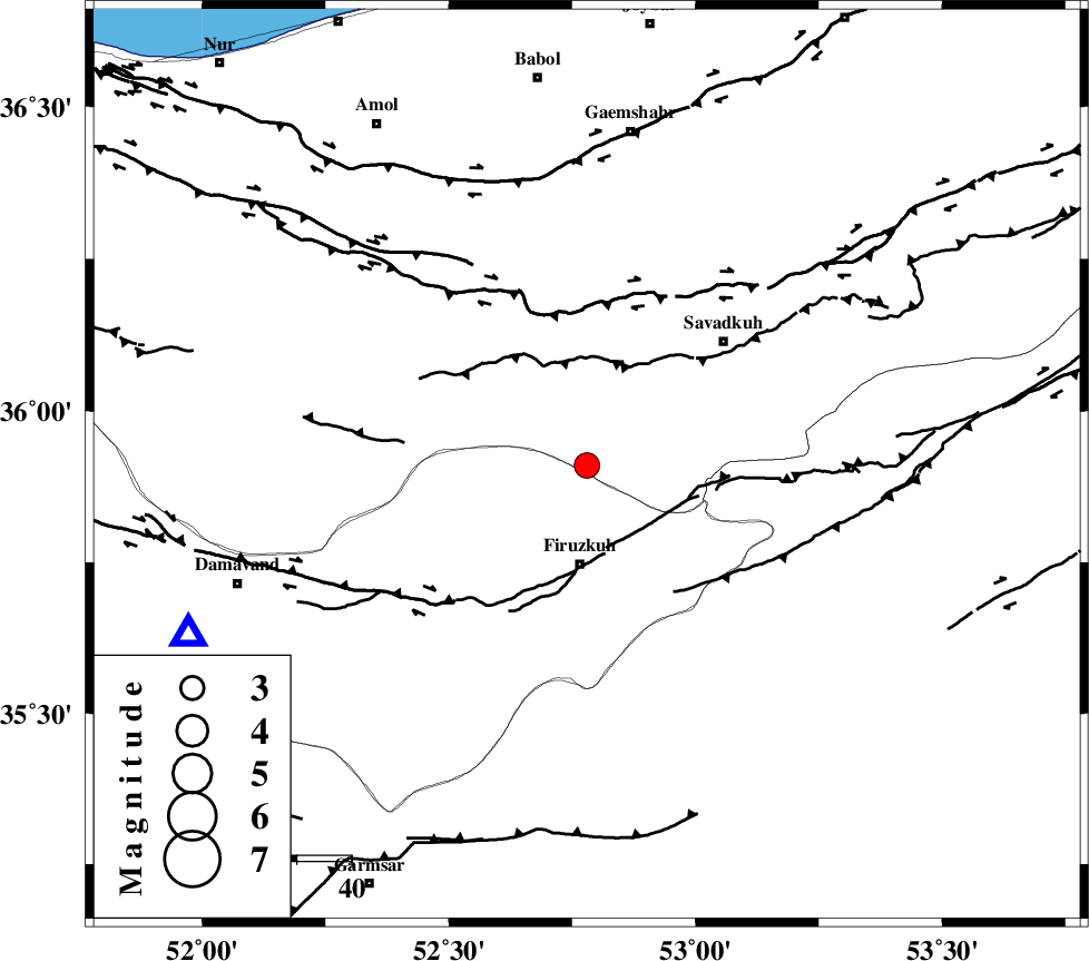
| Location | Lat:35.91 Lon: 52.78 |
| Region | Mazandaran Province, 18 km North of Firuzkuh |
Nearest Cities |
|
| 15 km North of Shahrabad, Tehran Province | |
| 17 km South of Alasht, Mazandaran Province | |
| 18 km North of Firuzkuh, Tehran Province | |
| 26 km North East of Arjomand, Tehran Province | |
| 27 km South West of Elahband, Mazandaran Province | |
| Depth | 14 km |
| Agency | |
Faults within 150 km: |
|
| MOSHA_F (Length: 234 km) , Distance to epicenter: 27 km | |
| ATARI_F (Length: 185 km) , Distance to epicenter: 28 km | |
| N_ALBORZ_F (Length: 360 km) , Distance to epicenter: 29 km | |
| Number of Phases | 6 |
| RMS | 0.2 |
| Number of Stations | 4 |
| Error in Latitude | >3.6 km |
| Error in Longitude | 7.2 km |
| Error in Depth | 8.3 km |
Download waveform in seisan format
to download seisan software Click here
to access information about IIEES stations Click here
Amplitude | ||||||||
| UID | Agency | Station | Component | Amplitude | Period | Arrival Time | Proccessing Time | Signal Clip |
| 91465 | IIEES | THKV | E | 339.4 | 0.4 | 2014-01-13 19:35:15 | 2014-01-13 07:57:00 | n |
| 91466 | IIEES | GHVR | E | 268.2 | 0.52 | 2014-01-13 19:35:31 | 2014-01-13 07:57:00 | n |
| 91467 | IIEES | GHVR | N | 198.6 | 0.6 | 2014-01-13 19:35:32 | 2014-01-13 07:57:00 | n |
Phase | ||||||||||||
| Agency | Station | Component | Phase Type | Phase Quality | First Motion | Observed Arrival Time | Time Residual | Loc. Flag | Input Weight | Distance | Azimuth | |
| IIEES | THKV | Z | Pg | E | 2014-01-13 19:34:50 | -0.04 | y | 171 | 271 | |||
| IIEES | THKV | E | Sg | E | 2014-01-13 19:35:11 | 0.19 | y | 171 | 271 | |||
| IIEES | GHVR | Z | Pn | E | 2014-01-13 19:34:56 | 0.25 | y | 211 | 222 | |||
| IIEES | ASAO | Z | Pn | E | 2014-01-13 19:35:05 | -0.09 | y | 292 | 240 | |||
| IIEES | ASAO | N | Sg | E | 2014-01-13 19:35:44 | -0.17 | y | 292 | 240 | |||
| IIEES | ZNJK | Z | Pn | E | 2014-01-13 19:35:16 | -0.2 | y | 377 | 284 | |||