
Magnitude |
:3.8 |
| Date & Time (UTC) | 2013-11-12 02:27:23.4 |
| Date & Time (Local) | 1392/8/21 05:57:23.4 |
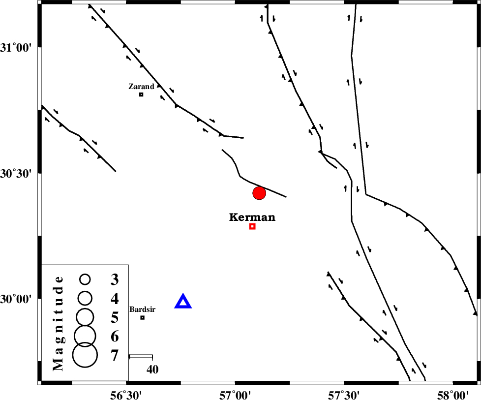
| Location | Lat:30.42 Lon: 57.11 |
| Region | Kerman Province, 15 km North of Kerman |
Nearest Cities |
|
| 15 km North of Kerman, Kerman Province | |
| 16 km North of Sarasiyab-e ferangi, Kerman Province | |
| 18 km West of Dehlulu, Kerman Province | |
| 19 km North East of Zangiabad, Kerman Province | |
| 20 km North East of Ekhtiyarabad, Kerman Province | |
| Depth | 14 km |
| Agency | |
Faults within 150 km: |
|
| CHATRUD_F (Length: 37 km) , Distance to epicenter: 3 km | |
| KUHBANAN_F (Length: 189 km) , Distance to epicenter: 25 km | |
| LAKARKUH_F (Length: 138 km) , Distance to epicenter: 33 km | |
| Number of Phases | 6 |
| RMS | 0.2 |
| Number of Stations | 5 |
| Error in Latitude | >4.4 km |
| Error in Longitude | 5.2 km |
| Error in Depth | 7.1 km |
Download waveform in seisan format
to download seisan software Click here
to access information about IIEES stations Click here
Amplitude | ||||||||
| UID | Agency | Station | Component | Amplitude | Period | Arrival Time | Proccessing Time | Signal Clip |
| 90976 | IIEES | TABS | N | 226.5 | 0.56 | 2013-11-12 02:29:10 | 2013-11-12 02:55:00 | n |
Phase | ||||||||||||
| Agency | Station | Component | Phase Type | Phase Quality | First Motion | Observed Arrival Time | Time Residual | Loc. Flag | Input Weight | Distance | Azimuth | |
| IIEES | KRBR | Z | Pg | E | 2013-11-12 02:27:34 | -0.04 | y | 59.5 | 215 | |||
| IIEES | BSRN | Z | Pn | E | 2013-11-12 02:28:03 | 0.04 | y | 257 | 48 | |||
| IIEES | YZKH | Z | Pn | E | 2013-11-12 02:28:11 | 0.3 | y | 324 | 313 | |||
| IIEES | TABS | Z | Pn | E | 2013-11-12 02:28:15 | -0.49 | y | 358 | 0 | |||
| IIEES | SHRT | Z | Pn | E | 2013-11-12 02:28:29 | 0.16 | y | 467 | 39 | |||
| IIEES | SHRT | N | Sg | E | 2013-11-12 02:29:33 | 0.06 | y | 467 | 39 | |||