
Magnitude |
:4.9 |
| Date & Time (UTC) | 2013-05-11 03:41:26.2 |
| Date & Time (Local) | 1392/2/21 08:11:26.2 |
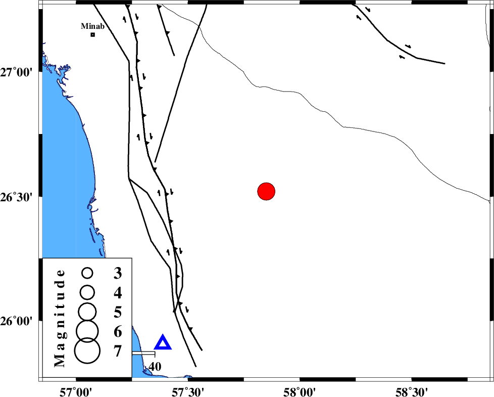
| Location | Lat:26.52 Lon: 57.85 |
| Region | Hormozgan Province, 99 km North of Jask |
Nearest Cities |
|
| 10 km of Angahran, Hormozgan Province | |
| 31 km South East of Darpahn, Hormozgan Province | |
| 54 km South East of Sanadrak, Hormozgan Province | |
| 65 km North East of Gonmardi, Hormozgan Province | |
| 66 km South of Keshmiran, Kerman Province | |
| Depth | 15 km |
| Agency | |
Faults within 150 km: |
|
| ZENDAN_MINAB_F_Z2 (Length: 63 km) , Distance to epicenter: 38 km | |
| ZENDAN_MINAB_F_Z1 (Length: 183 km) , Distance to epicenter: 44 km | |
| SABZEVARAN_F (Length: 190 km) , Distance to epicenter: 57 km | |
| Number of Phases | 6 |
| RMS | 0.4 |
| Number of Stations | 6 |
| Error in Latitude | >5.3 km |
| Error in Longitude | 2.1 km |
| Error in Depth | 0 km |
Download waveform in seisan format
to download seisan software Click here
to access information about IIEES stations Click here
Amplitude | ||||||||
| UID | Agency | Station | Component | Amplitude | Period | Arrival Time | Proccessing Time | Signal Clip |
| 89140 | IIEES | CHBR | N | 4816.4 | 0.78 | 2013-05-11 03:42:54 | 2013-05-11 05:05:00 | n |
Phase | ||||||||||||
| Agency | Station | Component | Phase Type | Phase Quality | First Motion | Observed Arrival Time | Time Residual | Loc. Flag | Input Weight | Distance | Azimuth | |
| IIEES | CHBR | Z | Pn | E | 2013-05-11 03:42:08 | -0.02 | y | 283 | 111 | |||
| IIEES | ZHSF | Z | Pn | E | 2013-05-11 03:42:29 | -0.11 | y | 447 | 39 | |||
| IIEES | GHIR | Z | Pn | E | 2013-05-11 03:42:38 | 0.02 | y | 519 | 293 | |||
| IIEES | AHRM | Z | Pn | E | 2013-05-11 03:43:00 | 0.2 | y | 696 | 293 | |||
| IIEES | YZKH | Z | Pn | E | 2013-05-11 03:43:03 | -0.58 | y | 723 | 335 | |||
| IIEES | SHRT | Z | Pn | E | 2013-05-11 03:43:16 | 0.73 | y | 824 | 16 | |||