
Magnitude |
:3.4 |
| Date & Time (UTC) | 2013-03-16 07:33:33.0 |
| Date & Time (Local) | 1391/12/26 11:03:33.0 |
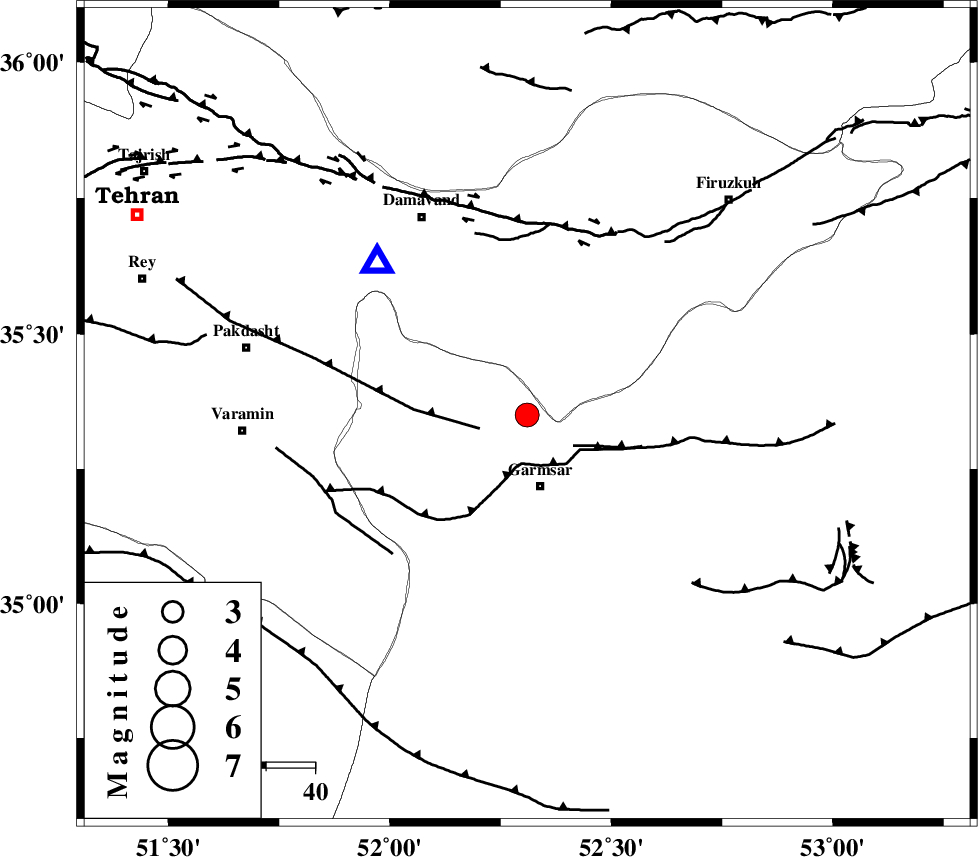
| Location | Lat:35.35 Lon: 52.31 |
| Region | Semnan Province, 15 km North of Garmsar |
Nearest Cities |
|
| 15 km North of Garmsar, Semnan Province | |
| 18 km North of Lajran, Semnan Province | |
| 21 km North West of Davarabad, Semnan Province | |
| 22 km North West of Gardovan, Semnan Province | |
| 22 km North West of Aradan, Semnan Province | |
| Depth | 6 km |
| Agency | |
Faults within 150 km: |
|
| GARMSAR_F (Length: 77 km) , Distance to epicenter: 10 km | |
| EYVANEKEY_F (Length: 74 km) , Distance to epicenter: 10 km | |
| PISHAV_F (Length: 34 km) , Distance to epicenter: 40 km | |
| Number of Phases | 6 |
| RMS | 0.3 |
| Number of Stations | 6 |
| Error in Latitude | >4.3 km |
| Error in Longitude | 5.7 km |
| Error in Depth | 7.1 km |
Download waveform in seisan format
to download seisan software Click here
to access information about IIEES stations Click here
Amplitude | ||||||||
| UID | Agency | Station | Component | Amplitude | Period | Arrival Time | Proccessing Time | Signal Clip |
| 88232 | IIEES | GHVR | E | 634.6 | 0.34 | 2013-03-16 07:34:20 | 2013-03-16 07:53:00 | n |
| 88233 | IIEES | GHVR | N | 705.2 | 0.39 | 2013-03-16 07:34:20 | 2013-03-16 07:53:00 | n |
Phase | ||||||||||||
| Agency | Station | Component | Phase Type | Phase Quality | First Motion | Observed Arrival Time | Time Residual | Loc. Flag | Input Weight | Distance | Azimuth | |
| IIEES | DAMV | Z | Pg | E | 2013-03-16 07:33:41 | 0.26 | y | 43.8 | 315 | |||
| IIEES | CHTH | Z | Pg | E | 2013-03-16 07:33:54 | -0.47 | y | 124 | 300 | |||
| IIEES | GHVR | Z | Pg | E | 2013-03-16 07:33:56 | 0.2 | y | 137 | 226 | |||
| IIEES | ASAO | Z | Pn | E | 2013-03-16 07:34:09 | -0.31 | y | 227 | 248 | |||
| IIEES | SHRO | Z | Pn | E | 2013-03-16 07:34:24 | -0.06 | y | 343 | 77 | |||
| IIEES | ZNJK | Z | Pn | E | 2013-03-16 07:34:26 | 0.44 | y | 358 | 295 | |||