
Magnitude |
:3.3 |
| Date & Time (UTC) | 2013-02-20 08:41:32.5 |
| Date & Time (Local) | 1391/12/2 12:11:32.5 |
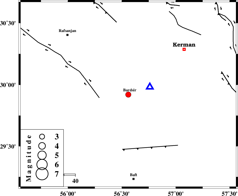
| Location | Lat:29.92 Lon: 56.56 |
| Region | Kerman Province, 1 km Bardsir |
Nearest Cities |
|
| 1 km of Bardsir, Kerman Province | |
| 11 km North West of Dashtkar, Kerman Province | |
| 16 km East of Mahutak, Kerman Province | |
| 24 km North West of Negar, Kerman Province | |
| 34 km North East of Tekyeh, Kerman Province | |
| Depth | 14 km |
| Agency | |
Faults within 150 km: |
|
| RAFSANJAN_F (Length: 129 km) , Distance to epicenter: 26 km | |
| LALEHZAR_F (Length: 52 km) , Distance to epicenter: 50 km | |
| DARIVAN_F (Length: 131 km) , Distance to epicenter: 66 km | |
| Number of Phases | 7 |
| RMS | 0.4 |
| Number of Stations | 5 |
| Error in Latitude | >11.4 km |
| Error in Longitude | 8.4 km |
| Error in Depth | 6.1 km |
Download waveform in seisan format
to download seisan software Click here
to access information about IIEES stations Click here
Amplitude | ||||||||
| UID | Agency | Station | Component | Amplitude | Period | Arrival Time | Proccessing Time | Signal Clip |
| 87978 | IIEES | KRBR | N | 5756.2 | 0.19 | 2013-02-20 08:41:40 | 2013-02-20 09:07:00 | n |
Phase | ||||||||||||
| Agency | Station | Component | Phase Type | Phase Quality | First Motion | Observed Arrival Time | Time Residual | Loc. Flag | Input Weight | Distance | Azimuth | |
| IIEES | KRBR | Z | Pg | E | 2013-02-20 08:41:37 | -0.06 | y | 20.5 | 70 | |||
| IIEES | KRBR | N | Sg | E | 2013-02-20 08:41:40 | -0.14 | y | 20.5 | 70 | |||
| IIEES | YZKH | Z | Pn | E | 2013-02-20 08:42:21 | -0.24 | y | 332 | 326 | |||
| IIEES | YZKH | E | Sg | E | 2013-02-20 08:43:06 | 0.22 | y | 332 | 326 | |||
| IIEES | ZHSF | Z | Pn | E | 2013-02-20 08:42:31 | 0.22 | y | 409 | 94 | |||
| IIEES | TABS | Z | Pn | E | 2013-02-20 08:42:31 | -0.59 | y | 417 | 7 | |||
| IIEES | SHRT | Z | Pn | E | 2013-02-20 08:42:48 | 0.81 | y | 544 | 40 | |||