
Magnitude |
:4.2 |
| Date & Time (UTC) | 2013-01-24 09:28:32.3 |
| Date & Time (Local) | 1391/11/5 12:58:32.3 |
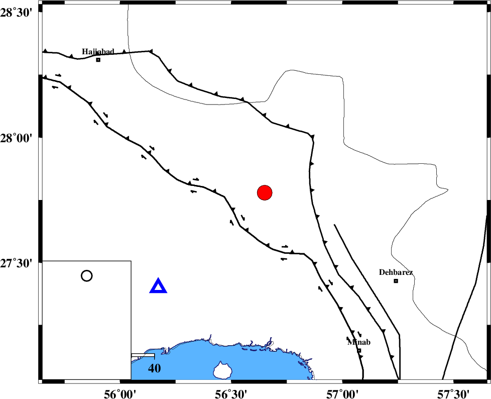
| Location | Lat:27.78 Lon: 56.65 |
| Region | Hormozgan Province, 70 km North-West of Dehbarez |
Nearest Cities |
|
| 49 km South East of Fareqan, Hormozgan Province | |
| 57 km North West of Ziaratali, Hormozgan Province | |
| 62 km West of Fariab, Hormozgan Province | |
| 66 km South West of Sarkhan, Kerman Province | |
| 67 km North West of Balashahr, Hormozgan Province | |
| Depth | 15 km |
| Agency | |
Faults within 150 km: |
|
| HZF2 (Length: 437 km) , Distance to epicenter: 16 km | |
| MAIN_ZAGROS_R_F (Length: 1106 km) , Distance to epicenter: 20 km | |
| ZENDAN_MINAB_F_Z1 (Length: 183 km) , Distance to epicenter: 34 km | |
| Number of Phases | 5 |
| RMS | 0.6 |
| Number of Stations | 5 |
| Error in Latitude | >7.3 km |
| Error in Longitude | 4.4 km |
| Error in Depth | 0 km |
Download waveform in seisan format
to download seisan software Click here
to access information about IIEES stations Click here
Amplitude | ||||||||
| UID | Agency | Station | Component | Amplitude | Period | Arrival Time | Proccessing Time | Signal Clip |
| 87698 | IIEES | KRBR | N | 1776.3 | 0.4 | 2013-01-24 09:29:43 | 2013-01-24 09:54:00 | n |
| 87699 | IIEES | AHRM | N | 125.9 | 0.52 | 2013-01-24 09:30:39 | 2013-01-24 09:54:00 | n |
Phase | ||||||||||||
| Agency | Station | Component | Phase Type | Phase Quality | First Motion | Observed Arrival Time | Time Residual | Loc. Flag | Input Weight | Distance | Azimuth | |
| IIEES | KRBR | Z | Pn | E | 2013-01-24 09:29:10 | -0.38 | y | 245 | 3 | |||
| IIEES | GHIR | Z | Pn | E | 2013-01-24 09:29:25 | 0.55 | y | 365 | 280 | |||
| IIEES | CHBR | Z | Pn | E | 2013-01-24 09:29:35 | -0.02 | y | 452 | 121 | |||
| IIEES | AHRM | Z | Pn | E | 2013-01-24 09:29:46 | -0.76 | y | 539 | 284 | |||
| IIEES | TABS | Z | Pn | E | 2013-01-24 09:30:01 | 0.84 | y | 653 | 4 | |||