
Magnitude |
:2.9 |
| Date & Time (UTC) | 2013-01-23 17:27:45.8 |
| Date & Time (Local) | 1391/11/4 20:57:45.8 |
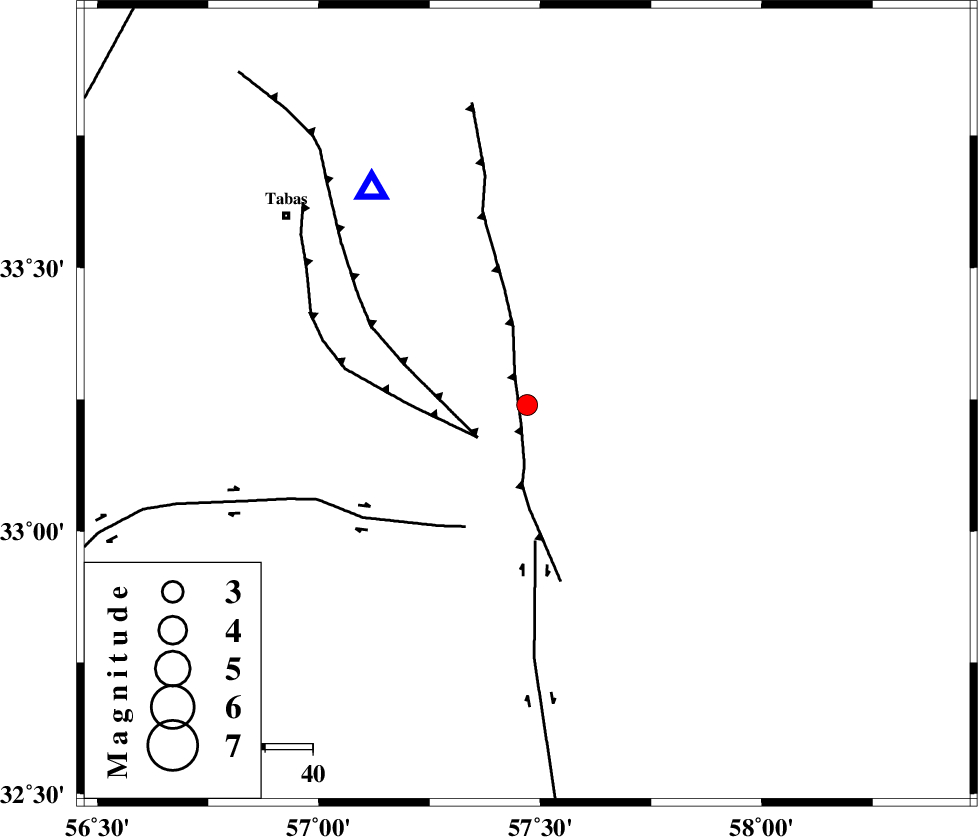
| Location | Lat:33.24 Lon: 57.47 |
| Region | Yazd Province, 65 km South-East of Tabas |
Nearest Cities |
|
| 6 km of Dihuk, Yazd Province | |
| 27 km North West of Arababad, Yazd Province | |
| 51 km South of Arsak, Khorasan(center) Province | |
| 55 km South East of Kerit, Yazd Province | |
| 63 km South East of Oshtoqran, Yazd Province | |
| Depth | 17 km |
| Agency | |
Faults within 150 km: |
|
| ESFARDIAR_F (Length: 94 km) , Distance to epicenter: 4 km | |
| TABAS_F2 (Length: 67 km) , Distance to epicenter: 12 km | |
| TABAS_F1 (Length: 91 km) , Distance to epicenter: 12 km | |
| Number of Phases | 6 |
| RMS | 0 |
| Number of Stations | 4 |
| Error in Latitude | >1.9 km |
| Error in Longitude | 2.2 km |
| Error in Depth | 4.9 km |
Download waveform in seisan format
to download seisan software Click here
to access information about IIEES stations Click here
Amplitude | ||||||||
| UID | Agency | Station | Component | Amplitude | Period | Arrival Time | Proccessing Time | Signal Clip |
| 87682 | IIEES | YZKH | N | 55.3 | 0.32 | 2013-01-23 17:29:10 | 2013-01-23 05:43:00 | n |
| 87683 | IIEES | YZKH | E | 57 | 0.44 | 2013-01-23 17:29:12 | 2013-01-23 05:43:00 | n |
| 87684 | IIEES | KRBR | N | 27.2 | 0.48 | 2013-01-23 17:29:39 | 2013-01-23 05:43:00 | n |
| 87685 | IIEES | KRBR | E | 29 | 0.48 | 2013-01-23 17:29:41 | 2013-01-23 05:43:00 | n |
Phase | ||||||||||||
| Agency | Station | Component | Phase Type | Phase Quality | First Motion | Observed Arrival Time | Time Residual | Loc. Flag | Input Weight | Distance | Azimuth | |
| IIEES | TABS | Z | Pg | E | 2013-01-23 17:27:55 | 0.03 | y | 56.4 | 325 | |||
| IIEES | TABS | E | Sg | E | 2013-01-23 17:28:03 | -0.02 | y | 56.4 | 325 | |||
| IIEES | SHRT | Z | Pn | E | 2013-01-23 17:28:26 | -0.01 | y | 266 | 79 | |||
| IIEES | YZKH | Z | Pn | E | 2013-01-23 17:28:28 | 0.02 | y | 285 | 252 | |||
| IIEES | YZKH | E | Sg | E | 2013-01-23 17:29:06 | -0.01 | y | 285 | 252 | |||
| IIEES | KRBR | Z | Pn | E | 2013-01-23 17:28:39 | -0.01 | y | 367 | 191 | |||