
Magnitude |
:3.8 |
| Date & Time (UTC) | 2013-01-03 18:25:18.5 |
| Date & Time (Local) | 1391/10/14 21:55:18.5 |
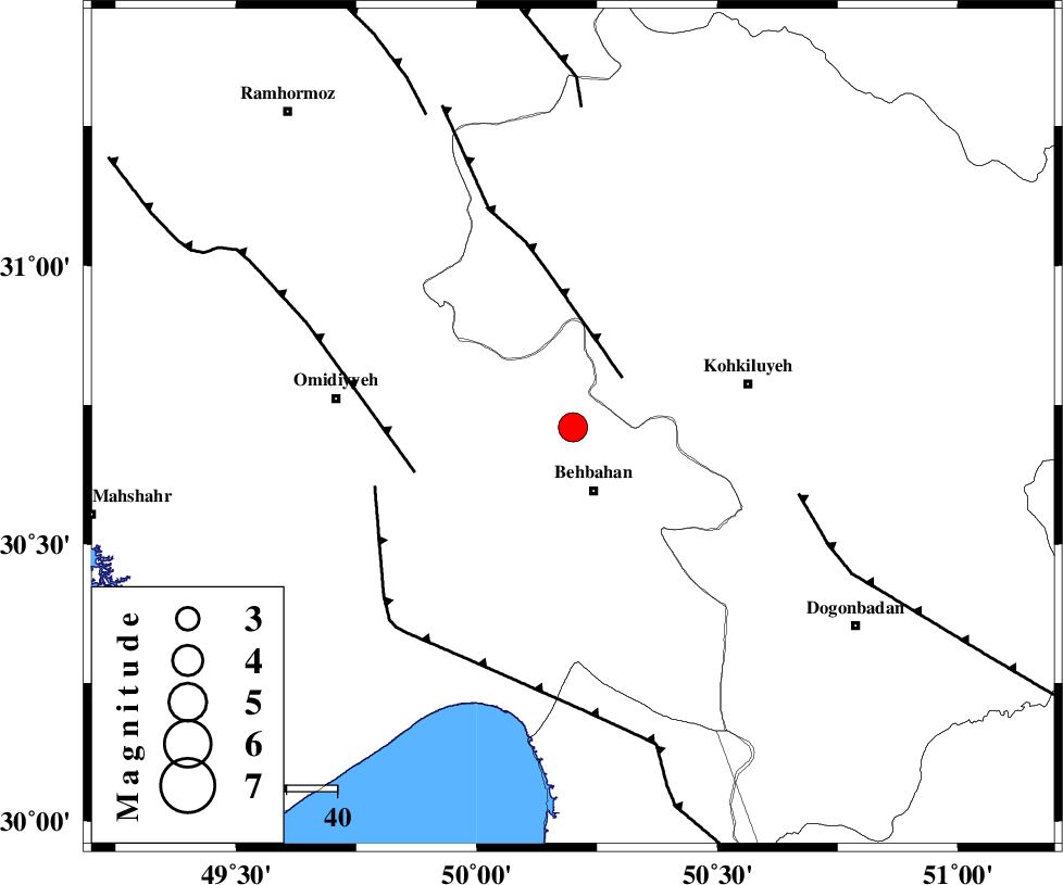
| Location | Lat:30.71 Lon: 50.2 |
| Region | Khoozestan Province, 14 km North of Behbahan |
Nearest Cities |
|
| 2 km of Dodange-ye bozorg, Khoozestan Province | |
| 13 km North of Mansuriyeh, Khoozestan Province | |
| 13 km North of Behbahan, Khoozestan Province | |
| 31 km South East of Jolaki, Khoozestan Province | |
| 35 km North East of Aghajari, Khoozestan Province | |
| Depth | 32 km |
| Agency | |
Faults within 150 km: |
|
| MFF4 (Length: 62 km) , Distance to epicenter: 14 km | |
| AGHAJARI_F (Length: 88 km) , Distance to epicenter: 33 km | |
| RAG_E_SEFID_F (Length: 84 km) , Distance to epicenter: 41 km | |
| Number of Phases | 6 |
| RMS | 0.2 |
| Number of Stations | 5 |
| Error in Latitude | >3.3 km |
| Error in Longitude | 6.2 km |
| Error in Depth | 8.1 km |
Download waveform in seisan format
to download seisan software Click here
to access information about IIEES stations Click here
Amplitude | ||||||||
| UID | Agency | Station | Component | Amplitude | Period | Arrival Time | Proccessing Time | Signal Clip |
| 87505 | IIEES | SHGR | E | 453.3 | 0.56 | 2013-01-03 18:26:36 | 2013-01-03 06:53:00 | n |
| 87506 | IIEES | SHGR | N | 639.7 | 0.72 | 2013-01-03 18:26:37 | 2013-01-03 06:53:00 | n |
| 87507 | IIEES | AHRM | E | 1287.8 | 0.64 | 2013-01-03 18:26:36 | 2013-01-03 06:53:00 | n |
Phase | ||||||||||||
| Agency | Station | Component | Phase Type | Phase Quality | First Motion | Observed Arrival Time | Time Residual | Loc. Flag | Input Weight | Distance | Azimuth | |
| IIEES | SHGR | Z | Pg | E | 2013-01-03 18:25:51 | -0.08 | y | 204 | 320 | |||
| IIEES | SHGR | E | Sg | E | 2013-01-03 18:26:15 | 0.08 | y | 204 | 320 | |||
| IIEES | AHRM | Z | Pn | E | 2013-01-03 18:25:53 | 0.07 | y | 231 | 152 | |||
| IIEES | KHMZ | Z | Pn | E | 2013-01-03 18:26:06 | 0.27 | y | 336 | 356 | |||
| IIEES | YZKH | Z | Pn | E | 2013-01-03 18:26:21 | -0.12 | y | 456 | 65 | |||
| IIEES | SNGE | Z | Pn | E | 2013-01-03 18:26:33 | -0.36 | y | 554 | 332 | |||