
Magnitude |
:3 |
| Date & Time (UTC) | 2012-12-28 17:06:57.5 |
| Date & Time (Local) | 1391/10/8 20:36:57.5 |
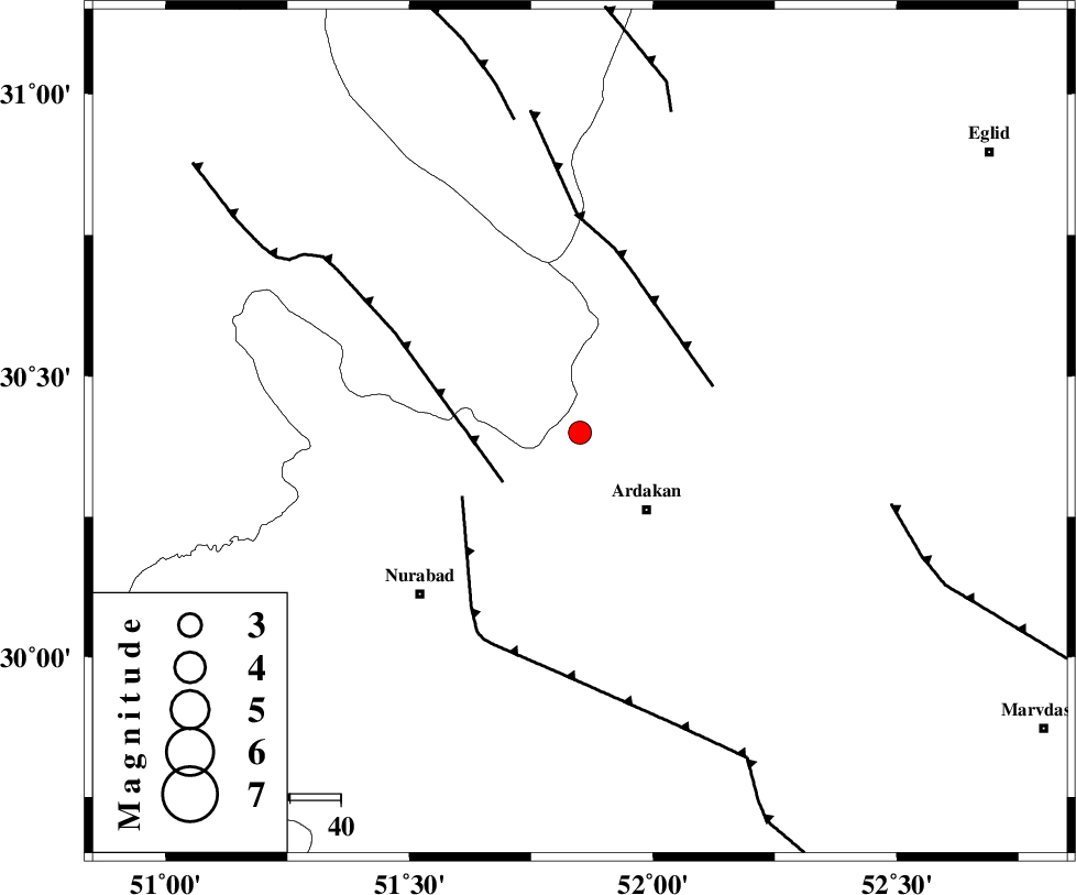
| Location | Lat:30.4 Lon: 51.85 |
| Region | Fars Province, 20 km North-West of Ardakan |
Nearest Cities |
|
| 6 km of Kamhar, Fars Province | |
| 20 km North West of Ardakan, Fars Province | |
| 26 km North West of Bahrghan, Fars Province | |
| 34 km South East of Tal-e khosro, Kohkiluieh va boyerahmad Province | |
| 37 km South East of Hoseynabad, Kohkiluieh va boyerahmad Province | |
| Depth | 14 km |
| Agency | |
Faults within 150 km: |
|
| HZF3 (Length: 197 km) , Distance to epicenter: 10 km | |
| KAZERUN_F (Length: 96 km) , Distance to epicenter: 31 km | |
| DENA_F (Length: 137 km) , Distance to epicenter: 45 km | |
| Number of Phases | 5 |
| RMS | 0.2 |
| Number of Stations | 4 |
| Error in Latitude | >5.2 km |
| Error in Longitude | 5.5 km |
| Error in Depth | 18.2 km |
Download waveform in seisan format
to download seisan software Click here
to access information about IIEES stations Click here
Amplitude | ||||||||
| UID | Agency | Station | Component | Amplitude | Period | Arrival Time | Proccessing Time | Signal Clip |
| 87463 | IIEES | AHRM | E | 251.4 | 0.4 | 2012-12-28 17:07:51 | 2012-12-28 05:42:00 | n |
| 87464 | IIEES | AHRM | N | 277.4 | 0.52 | 2012-12-28 17:07:51 | 2012-12-28 05:42:00 | n |
| 87465 | IIEES | KRBR | E | 13.7 | 0.6 | 2012-12-28 17:09:19 | 2012-12-28 05:42:00 | n |
| 87466 | IIEES | KRBR | N | 12 | 0.76 | 2012-12-28 17:09:21 | 2012-12-28 05:42:00 | n |
Phase | ||||||||||||
| Agency | Station | Component | Phase Type | Phase Quality | First Motion | Observed Arrival Time | Time Residual | Loc. Flag | Input Weight | Distance | Azimuth | |
| IIEES | AHRM | Z | Pg | E | 2012-12-28 17:07:26 | -0.23 | y | 178 | 198 | |||
| IIEES | AHRM | N | Sg | E | 2012-12-28 17:07:48 | 0.2 | y | 178 | 198 | |||
| IIEES | YZKH | Z | Pn | E | 2012-12-28 17:07:48 | 0.21 | y | 342 | 49 | |||
| IIEES | KHMZ | Z | Pn | E | 2012-12-28 17:07:56 | -0.04 | y | 411 | 335 | |||
| IIEES | KRBR | Z | Pn | E | 2012-12-28 17:08:04 | -0.17 | y | 475 | 94 | |||