
Magnitude |
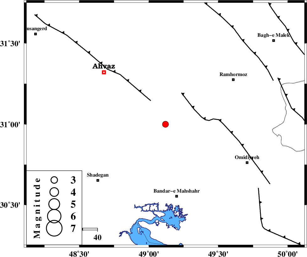
:2.8 |
| Date & Time (UTC) | 2012-12-24 18:56:10.9 |
| Date & Time (Local) | 1391/10/4 22:26:10.9 |
| Location | Lat:31 Lon: 49.12 |
| Region | Khoozestan Province, 51 km North of Bandar-e mahshahr |
Nearest Cities |
|
| 28 km South East of Mashrehat, Khoozestan Province | |
| 29 km North West of Ramshir, Khoozestan Province | |
| 30 km West of Meshrageh, Khoozestan Province | |
| 32 km North of Hashtcheh sofla, Khoozestan Province | |
| 35 km North West of Abdoliyeh, Khoozestan Province | |
| Depth | 14 km |
| Agency | |
Faults within 150 km: |
|
| AHVAZ_F (Length: 99 km) , Distance to epicenter: 19 km | |
| AGHAJARI_F (Length: 88 km) , Distance to epicenter: 22 km | |
| RAG_E_SEFID_F (Length: 84 km) , Distance to epicenter: 77 km | |
| Number of Phases | 5 |
| RMS | 0.2 |
| Number of Stations | 3 |
| Error in Latitude | >5.5 km |
| Error in Longitude | 6 km |
| Error in Depth | 8.4 km |
Download waveform in seisan format
to download seisan software Click here
to access information about IIEES stations Click here
Amplitude | ||||||||
| UID | Agency | Station | Component | Amplitude | Period | Arrival Time | Proccessing Time | Signal Clip |
| 87414 | IIEES | SHGR | N | 208 | 0.28 | 2012-12-24 18:56:51 | 2012-12-24 07:47:00 | n |
| 87415 | IIEES | SHGR | E | 245.5 | 0.29 | 2012-12-24 18:56:52 | 2012-12-24 07:47:00 | n |
Phase | ||||||||||||
| Agency | Station | Component | Phase Type | Phase Quality | First Motion | Observed Arrival Time | Time Residual | Loc. Flag | Input Weight | Distance | Azimuth | |
| IIEES | SHGR | Z | Pg | E | 2012-12-24 18:56:31 | -0.22 | y | 126 | 346 | |||
| IIEES | SHGR | N | Sg | E | 2012-12-24 18:56:47 | 0.13 | y | 126 | 346 | |||
| IIEES | KHMZ | Z | Pn | E | 2012-12-24 18:56:57 | 0.21 | y | 314 | 14 | |||
| IIEES | KHMZ | E | Sg | E | 2012-12-24 18:57:39 | -0.09 | y | 314 | 14 | |||
| IIEES | ASAO | Z | Pn | E | 2012-12-24 18:57:08 | -0.02 | y | 402 | 12 | |||