
Magnitude |
:3.9 |
| Date & Time (UTC) | 2012-12-13 22:03:37.4 |
| Date & Time (Local) | 1391/9/24 01:33:37.4 |
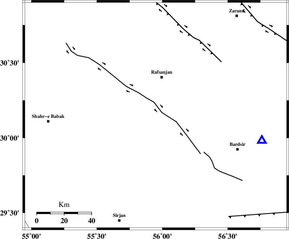
| Location | Lat:30.15 Lon: 55.95 |
| Region | Kerman Province, 29 km South of Rafsanjan |
Nearest Cities |
|
| 29 km South of Rafsanjan, Kerman Province | |
| 33 km South West of Qasemabad, Kerman Province | |
| 36 km North East of Pariz, Kerman Province | |
| 43 km South West of Kabutarkhan, Kerman Province | |
| 48 km North West of Mahutak, Kerman Province | |
| Depth | 14 km |
| Agency | |
Faults within 150 km: |
|
| RAFSANJAN_F (Length: 129 km) , Distance to epicenter: 5 km | |
| SHAHR_E_BABAK_F2 (Length: 272 km) , Distance to epicenter: 59 km | |
| DARIVAN_F (Length: 131 km) , Distance to epicenter: 62 km | |
| Number of Phases | 5 |
| RMS | 0.2 |
| Number of Stations | 4 |
| Error in Latitude | >3.5 km |
| Error in Longitude | 7.7 km |
| Error in Depth | 9.2 km |
Download waveform in seisan format
to download seisan software Click here
to access information about IIEES stations Click here
Amplitude | ||||||||
| UID | Agency | Station | Component | Amplitude | Period | Arrival Time | Proccessing Time | Signal Clip |
| 87338 | IIEES | YZKH | E | 645.6 | 0.48 | 2012-12-13 22:04:57 | 2012-12-13 10:30:00 | n |
| 87339 | IIEES | YZKH | N | 441 | 0.6 | 2012-12-13 22:05:02 | 2012-12-13 10:30:00 | n |
Phase | ||||||||||||
| Agency | Station | Component | Phase Type | Phase Quality | First Motion | Observed Arrival Time | Time Residual | Loc. Flag | Input Weight | Distance | Azimuth | |
| IIEES | KRBR | Z | Pg | E | 2012-12-13 22:03:51 | -0.16 | y | 80.6 | 103 | |||
| IIEES | YZKH | Z | Pn | E | 2012-12-13 22:04:19 | -0.09 | y | 280 | 333 | |||
| IIEES | TABS | Z | Pn | E | 2012-12-13 22:04:35 | 0.07 | y | 404 | 16 | |||
| IIEES | TABS | N | Sg | E | 2012-12-13 22:05:30 | -0.14 | y | 404 | 16 | |||
| IIEES | SHRT | Z | Pn | E | 2012-12-13 22:04:55 | 0.51 | y | 565 | 46 | |||