
Magnitude |
:3.8 |
| Date & Time (UTC) | 2012-12-02 19:38:54.1 |
| Date & Time (Local) | 1391/9/12 23:08:54.1 |
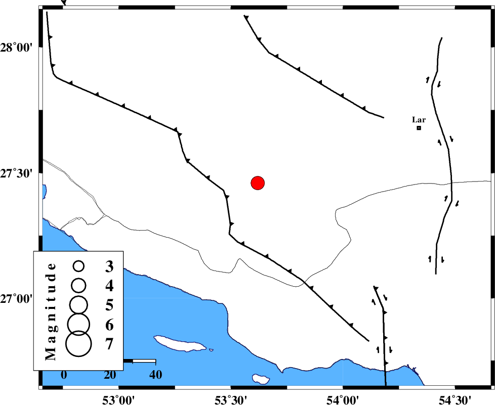
| Location | Lat:27.4 Lon: 53.66 |
| Region | Fars Province, 50 km East of Lamerd |
Nearest Cities |
|
| 15 km East of Beyram, Fars Province | |
| 20 km North of Ashkenan, Fars Province | |
| 25 km South East of Fedagh, Fars Province | |
| 27 km North of Ahl, Fars Province | |
| 37 km South of Ard, Fars Province | |
| Depth | 16 km |
| Agency | |
Faults within 150 km: |
|
| LAR_F (Length: 99 km) , Distance to epicenter: 36 km | |
| MFF3 (Length: 292 km) , Distance to epicenter: 37 km | |
| MFF1 (Length: 180 km) , Distance to epicenter: 53 km | |
| Number of Phases | 8 |
| RMS | 0.1 |
| Number of Stations | 6 |
| Error in Latitude | >3.4 km |
| Error in Longitude | 2.8 km |
| Error in Depth | 6.3 km |
Download waveform in seisan format
to download seisan software Click here
to access information about IIEES stations Click here
Amplitude | ||||||||
| UID | Agency | Station | Component | Amplitude | Period | Arrival Time | Proccessing Time | Signal Clip |
| 87234 | IIEES | KRBR | E | 144.1 | 0.52 | 2012-12-02 19:40:57 | 2012-12-02 08:50:00 | n |
| 87235 | IIEES | KRBR | N | 145.8 | 0.76 | 2012-12-02 19:41:15 | 2012-12-02 08:50:00 | n |
Phase | ||||||||||||
| Agency | Station | Component | Phase Type | Phase Quality | First Motion | Observed Arrival Time | Time Residual | Loc. Flag | Input Weight | Distance | Azimuth | |
| IIEES | AHRM | Z | Pn | E | 2012-12-02 19:39:36 | -0.06 | y | 283 | 305 | |||
| IIEES | AHRM | E | Sg | E | 2012-12-02 19:40:13 | 0.08 | y | 283 | 305 | |||
| IIEES | KRBR | Z | Pn | E | 2012-12-02 19:39:53 | -0.23 | y | 416 | 46 | |||
| IIEES | KRBR | N | S | E | 2012-12-02 19:40:37 | 0.13 | y | 416 | 46 | |||
| IIEES | CHBR | Z | Pn | E | 2012-12-02 19:40:29 | 0.22 | y | 708 | 105 | |||
| IIEES | TABS | Z | Pn | E | 2012-12-02 19:40:37 | -0.05 | y | 768 | 25 | |||
| IIEES | KHMZ | Z | Pn | E | 2012-12-02 19:40:39 | -0.01 | y | 787 | 334 | |||
| IIEES | SHRO | Z | Pn | E | 2012-12-02 19:41:03 | -0.08 | y | 980 | 13 | |||