
Magnitude |
:4.7 |
| Date & Time (UTC) | 2012-11-27 06:22:26.0 |
| Date & Time (Local) | 1391/9/7 09:52:26.0 |
| Location | Lat:33.26 Lon: 49.41 |
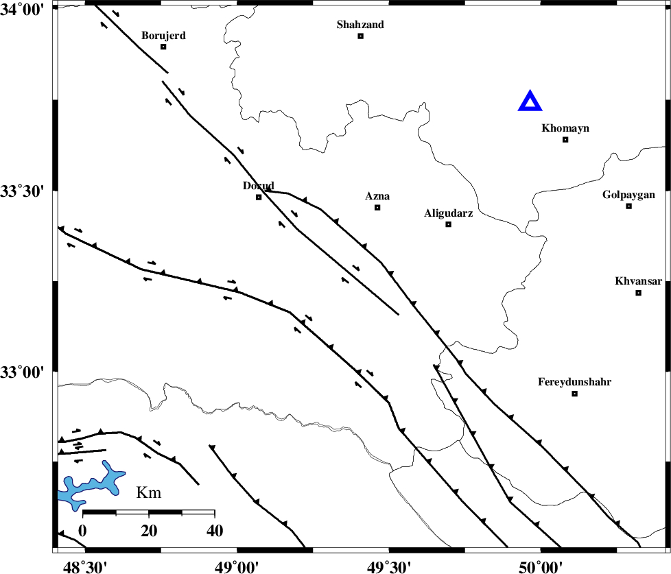
| Region | Lorestan Province, 22 km South of Azna |
Nearest Cities |
|
| 22 km South of Azna, Lorestan Province | |
| 22 km South of Darband, Lorestan Province | |
| 23 km South West of Sur, Lorestan Province | |
| 23 km North East of Shulabad, Lorestan Province | |
| 28 km North West of Shapoorabad, Lorestan Province | |
| Depth | 18 km |
| Agency | |
Faults within 150 km: |
|
| MAIN_ZAGROS_R_F (Length: 1106 km) , Distance to epicenter: 7 km | |
| DORUD (Length: 100 km) , Distance to epicenter: 16 km | |
| HZF4 (Length: 492 km) , Distance to epicenter: 24 km | |
| Number of Phases | 6 |
| RMS | 0.1 |
| Number of Stations | 5 |
| Error in Latitude | >3.5 km |
| Error in Longitude | 4.3 km |
| Error in Depth | 4.9 km |
Download waveform in seisan format
to download seisan software Click here
to access information about IIEES stations Click here
Amplitude | ||||||||
| UID | Agency | Station | Component | Amplitude | Period | Arrival Time | Proccessing Time | Signal Clip |
| 87171 | IIEES | KHMZ | N | 32417.6 | 0.67 | 2012-11-27 06:22:52 | 2012-11-27 07:00:00 | n |
| 87172 | IIEES | SHGR | N | 12499.7 | 0.5 | 2012-11-27 06:23:16 | 2012-11-27 07:00:00 | n |
| 87173 | IIEES | SHGR | E | 15632.1 | 0.64 | 2012-11-27 06:23:16 | 2012-11-27 07:00:00 | n |
Phase | ||||||||||||
| Agency | Station | Component | Phase Type | Phase Quality | First Motion | Observed Arrival Time | Time Residual | Loc. Flag | Input Weight | Distance | Azimuth | |
| IIEES | KHMZ | Z | Pg | E | 2012-11-27 06:22:39 | 0.14 | y | 74.2 | 44 | |||
| IIEES | KHMZ | N | Sg | E | 2012-11-27 06:22:48 | -0.05 | y | 74.2 | 44 | |||
| IIEES | SHGR | Z | Pn | E | 2012-11-27 06:22:50 | 0.02 | y | 140 | 204 | |||
| IIEES | ASAO | Z | Pg | E | 2012-11-27 06:22:51 | -0.11 | y | 154 | 22 | |||
| IIEES | GHVR | Z | Pn | E | 2012-11-27 06:23:00 | 0.06 | y | 217 | 51 | |||
| IIEES | KRBR | Z | Pn | E | 2012-11-27 06:24:11 | -0.16 | y | 787 | 116 | |||