
Magnitude |
:3 |
| Date & Time (UTC) | 2012-11-10 01:46:16.0 |
| Date & Time (Local) | 1391/8/20 05:16:16.0 |
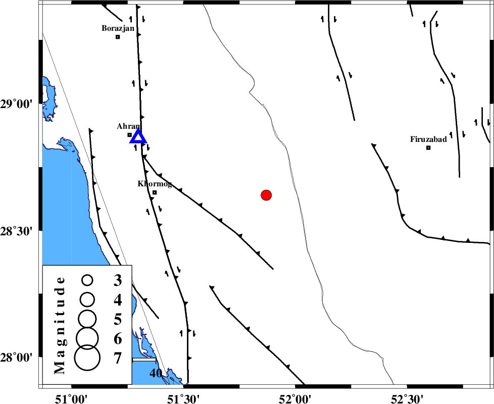
| Location | Lat:28.64 Lon: 51.87 |
| Region | Bushehr Province, 33 km South-West of Farashband |
Nearest Cities |
|
| 30 km North East of Shanbeh, Bushehr Province | |
| 33 km South West of Farashband, Fars Province | |
| 36 km South West of Aviz, Fars Province | |
| 46 km North East of Baduleh, Bushehr Province | |
| 46 km North West of Dahrom, Fars Province | |
| Depth | 28 km |
| Agency | |
Faults within 150 km: |
|
| MFF5 (Length: 74 km) , Distance to epicenter: 21 km | |
| MFF3 (Length: 292 km) , Distance to epicenter: 47 km | |
| BORAZJAN_F (Length: 168 km) , Distance to epicenter: 49 km | |
| Number of Phases | 6 |
| RMS | 0.1 |
| Number of Stations | 4 |
| Error in Latitude | >11.7 km |
| Error in Longitude | 6 km |
| Error in Depth | 9.3 km |
Download waveform in seisan format
to download seisan software Click here
to access information about IIEES stations Click here
Amplitude | ||||||||
| UID | Agency | Station | Component | Amplitude | Period | Arrival Time | Proccessing Time | Signal Clip |
| 86949 | IIEES | AHRM | N | 638 | 0.48 | 2012-11-10 01:46:51 | 2012-11-10 03:08:00 | n |
| 86950 | IIEES | GHIR | E | 484.9 | 0.4 | 2012-11-10 01:46:59 | 2012-11-10 03:08:00 | n |
Phase | ||||||||||||
| Agency | Station | Component | Phase Type | Phase Quality | First Motion | Observed Arrival Time | Time Residual | Loc. Flag | Input Weight | Distance | Azimuth | |
| IIEES | AHRM | Z | Pg | E | 2012-11-10 01:46:27 | -0.02 | y | 60.9 | 294 | |||
| IIEES | GHIR | Z | Pg | E | 2012-11-10 01:46:35 | 0.12 | y | 117 | 109 | |||
| IIEES | GHIR | E | Sg | E | 2012-11-10 01:46:49 | -0.07 | y | 117 | 109 | |||
| IIEES | YZKH | Z | Pn | E | 2012-11-10 01:47:23 | 0.03 | y | 491 | 32 | |||
| IIEES | KRBR | Z | Pn | E | 2012-11-10 01:47:24 | -0.13 | y | 498 | 71 | |||
| IIEES | KRBR | N | S | E | 2012-11-10 01:48:14 | 0.05 | y | 498 | 71 | |||