
Magnitude |
:3.2 |
| Date & Time (UTC) | 2012-10-31 11:18:44.8 |
| Date & Time (Local) | 1391/8/10 14:48:44.8 |
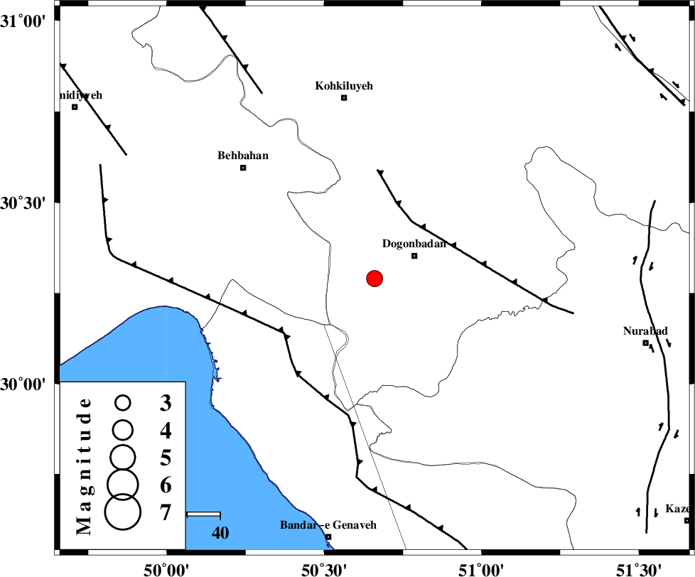
| Location | Lat:30.29 Lon: 50.66 |
| Region | Kohkiluieh va boyerahmad Province, 14 km West of Dogonbadan |
Nearest Cities |
|
| 14 km West of Dogonbadan, Kohkiluieh va boyerahmad Province | |
| 41 km North East of Siyahmakan-e bozorg, Bushehr Province | |
| 41 km South West of Abdehgah, Kohkiluieh va boyerahmad Province | |
| 42 km East of Sardasht, Khoozestan Province | |
| 48 km North East of Ameri, Bushehr Province | |
| Depth | 36 km |
| Agency | |
Faults within 150 km: |
|
| MISHAN_F (Length: 76 km) , Distance to epicenter: 21 km | |
| ZFF3 (Length: 125 km) , Distance to epicenter: 32 km | |
| RAG_E_SEFID_F (Length: 84 km) , Distance to epicenter: 32 km | |
| Number of Phases | 4 |
| RMS | 0 |
| Number of Stations | 4 |
| Error in Latitude | >3.1 km |
| Error in Longitude | 6.3 km |
| Error in Depth | 6 km |
Download waveform in seisan format
to download seisan software Click here
to access information about IIEES stations Click here
Amplitude | ||||||||
| UID | Agency | Station | Component | Amplitude | Period | Arrival Time | Proccessing Time | Signal Clip |
| 86786 | IIEES | AHRM | N | 254.2 | 0.45 | 2012-10-31 11:19:38 | 2012-10-31 11:06:00 | n |
| 86787 | IIEES | GHIR | E | 84.9 | 0.53 | 2012-10-31 11:20:21 | 2012-10-31 11:06:00 | n |
| 86788 | IIEES | YZKH | N | 31.1 | 0.36 | 2012-10-31 11:20:35 | 2012-10-31 11:06:00 | n |
Phase | ||||||||||||
| Agency | Station | Component | Phase Type | Phase Quality | First Motion | Observed Arrival Time | Time Residual | Loc. Flag | Input Weight | Distance | Azimuth | |
| IIEES | AHRM | Z | Pg | E | 2012-10-31 11:19:12 | -0.01 | y | 170 | 158 | |||
| IIEES | GHIR | Z | Pn | E | 2012-10-31 11:19:30 | 0 | y | 317 | 134 | |||
| IIEES | YZKH | Z | Pn | E | 2012-10-31 11:19:45 | 0.01 | y | 441 | 57 | |||
| IIEES | ASAO | Z | P | E | 2012-10-31 11:19:49 | 0 | y | 476 | 353 | |||