
Magnitude |
:3.2 |
| Date & Time (UTC) | 2012-10-27 10:59:46.9 |
| Date & Time (Local) | 1391/8/6 14:29:46.9 |
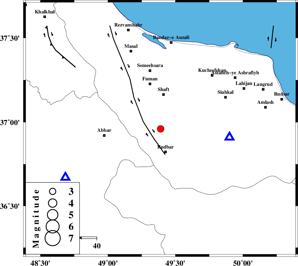
| Location | Lat:36.96 Lon: 49.39 |
| Region | Gilan Province, 16 km North of Rudbar |
Nearest Cities |
|
| 10 km West of Nasir mahalleh, Gilan Province | |
| 14 km North of Rostamabad, Gilan Province | |
| 16 km North of Rudbar, Gilan Province | |
| 19 km East of Siyahmargi, Gilan Province | |
| 20 km South of Chobareh, Gilan Province | |
| Depth | 15 km |
| Agency | |
Faults within 150 km: |
|
| LAHIJAN_F (Length: 92 km) , Distance to epicenter: 6 km | |
| RUDBAR_F (Length: 93 km) , Distance to epicenter: 16 km | |
| TALESH_F (Length: 258 km) , Distance to epicenter: 31 km | |
| Number of Phases | 5 |
| RMS | 0.4 |
| Number of Stations | 5 |
| Error in Latitude | >6 km |
| Error in Longitude | 5.6 km |
| Error in Depth | 6.7 km |
Download waveform in seisan format
to download seisan software Click here
to access information about IIEES stations Click here
Amplitude | ||||||||
| UID | Agency | Station | Component | Amplitude | Period | Arrival Time | Proccessing Time | Signal Clip |
| 86747 | IIEES | GRMI | E | 147.5 | 0.55 | 2012-10-27 11:00:57 | 2012-10-27 11:25:00 | n |
| 86748 | IIEES | GRMI | N | 135.8 | 0.44 | 2012-10-27 11:00:58 | 2012-10-27 11:25:00 | n |
| 86749 | IIEES | GHVR | E | 80.3 | 0.38 | 2012-10-27 11:01:23 | 2012-10-27 11:25:00 | n |
Phase | ||||||||||||
| Agency | Station | Component | Phase Type | Phase Quality | First Motion | Observed Arrival Time | Time Residual | Loc. Flag | Input Weight | Distance | Azimuth | |
| IIEES | ZNJK | Z | Pg | E | 2012-10-27 10:59:59 | -0.24 | y | 70.6 | 243 | |||
| IIEES | CHTH | Z | Pg | E | 2012-10-27 11:00:18 | -0.18 | y | 195 | 126 | |||
| IIEES | GRMI | Z | Pn | E | 2012-10-27 11:00:24 | 0.1 | y | 244 | 328 | |||
| IIEES | ASAO | Z | Pn | E | 2012-10-27 11:00:29 | 0.67 | y | 274 | 168 | |||
| IIEES | GHVR | Z | Pn | E | 2012-10-27 11:00:34 | -0.35 | y | 322 | 148 | |||