
Magnitude |
:3.4 |
| Date & Time (UTC) | 2012-10-23 11:56:40.1 |
| Date & Time (Local) | 1391/8/2 15:26:40.1 |
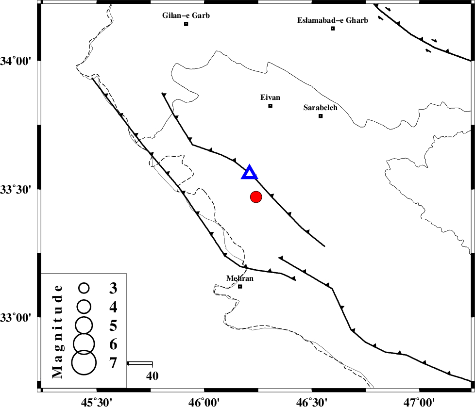
| Location | Lat:33.47 Lon: 46.24 |
| Region | Ilam Province, 26 km South-West of Ilam |
Nearest Cities |
|
| 5 km of Salehabad, Ilam Province | |
| 21 km North West of Mehr, Ilam Province | |
| 23 km North West of Galeh-yedarre-hemalakshahi, Ilam Province | |
| 24 km South of Chavar, Ilam Province | |
| 26 km South West of Ilam, Ilam Province | |
| Depth | 14 km |
| Agency | |
Faults within 150 km: |
|
| MFF7 (Length: 99 km) , Distance to epicenter: 8 km | |
| ZFF4 (Length: 128 km) , Distance to epicenter: 25 km | |
| MFF6 (Length: 144 km) , Distance to epicenter: 28 km | |
| Number of Phases | 7 |
| RMS | 0.2 |
| Number of Stations | 6 |
| Error in Latitude | >4.6 km |
| Error in Longitude | 9 km |
| Error in Depth | 7.5 km |
Download waveform in seisan format
to download seisan software Click here
to access information about IIEES stations Click here
Amplitude | ||||||||
| UID | Agency | Station | Component | Amplitude | Period | Arrival Time | Proccessing Time | Signal Clip |
| 86716 | IIEES | SNGE | N | 255.6 | 0.73 | 2012-10-23 11:57:44 | 2012-10-23 12:25:00 | n |
| 86717 | IIEES | SNGE | E | 502.8 | 0.43 | 2012-10-23 11:57:45 | 2012-10-23 12:25:00 | n |
Phase | ||||||||||||
| Agency | Station | Component | Phase Type | Phase Quality | First Motion | Observed Arrival Time | Time Residual | Loc. Flag | Input Weight | Distance | Azimuth | |
| IIEES | SNGE | Z | Pg | E | 2012-10-23 11:57:14 | -0.16 | y | 207 | 29 | |||
| IIEES | SNGE | N | Sg | E | 2012-10-23 11:57:39 | 0.04 | y | 207 | 29 | |||
| IIEES | KHMZ | Z | Pn | E | 2012-10-23 11:57:31 | 0.07 | y | 347 | 84 | |||
| IIEES | ASAO | Z | Pn | E | 2012-10-23 11:57:34 | 0.16 | y | 370 | 70 | |||
| IIEES | ZNJK | Z | Pn | E | 2012-10-23 11:57:40 | 0.22 | y | 420 | 31 | |||
| IIEES | GHVR | Z | Pn | E | 2012-10-23 11:57:46 | -0.17 | y | 476 | 75 | |||
| IIEES | CHTH | Z | Pn | E | 2012-10-23 11:57:52 | -0.19 | y | 524 | 57 | |||