
Magnitude |
:3.3 |
| Date & Time (UTC) | 2012-10-19 01:04:05.8 |
| Date & Time (Local) | 1391/7/28 04:34:05.8 |
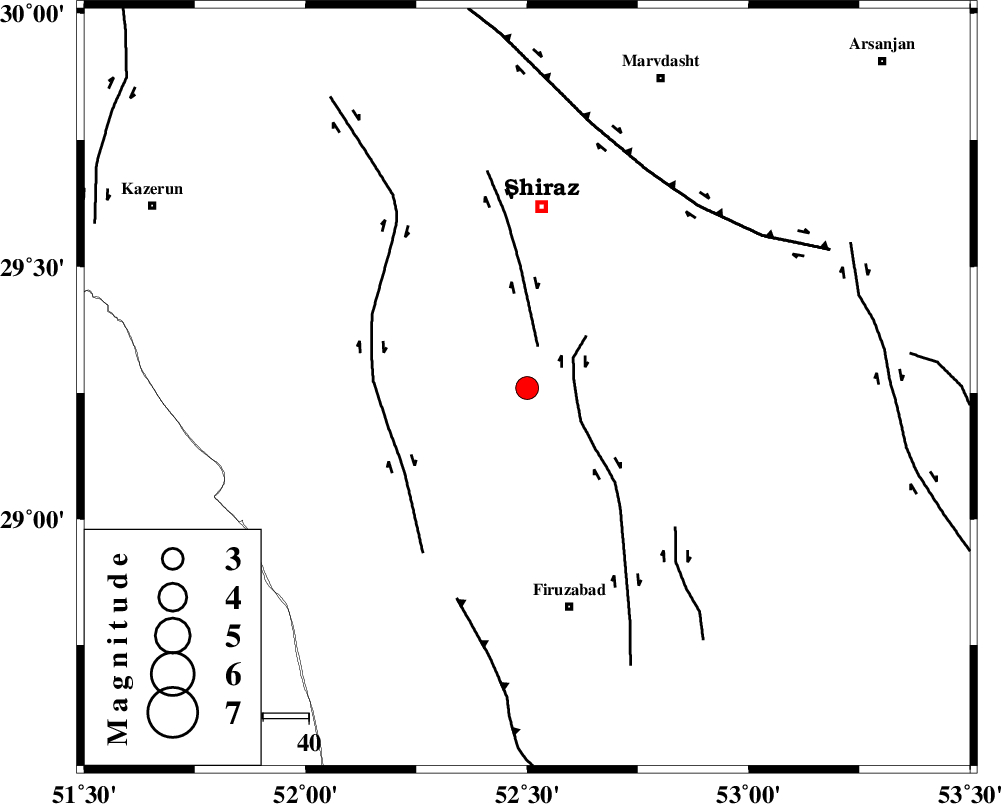
| Location | Lat:29.26 Lon: 52.5 |
| Region | Fars Province, 40 km South of Shiraz |
Nearest Cities |
|
| 19 km West of Tasuj, Fars Province | |
| 24 km North West of Kavar, Fars Province | |
| 25 km North of Jokan, Fars Province | |
| 27 km North West of Akbarabad, Fars Province | |
| 31 km South of Soltanabad, Fars Province | |
| Depth | 41 km |
| Agency | |
Faults within 150 km: |
|
| SABZ_PUSHAN_F_Z3 (Length: 37 km) , Distance to epicenter: 10 km | |
| SABZ_PUSHAN_F_Z1 (Length: 69 km) , Distance to epicenter: 10 km | |
| KAREBASS_F (Length: 98 km) , Distance to epicenter: 32 km | |
| Number of Phases | 6 |
| RMS | 0.1 |
| Number of Stations | 6 |
| Error in Latitude | >2.4 km |
| Error in Longitude | 2 km |
| Error in Depth | 4.1 km |
Download waveform in seisan format
to download seisan software Click here
to access information about IIEES stations Click here
Amplitude | ||||||||
| UID | Agency | Station | Component | Amplitude | Period | Arrival Time | Proccessing Time | Signal Clip |
| 86661 | IIEES | GHIR | E | 584.2 | 0.32 | 2012-10-19 01:04:47 | 2012-10-19 02:02:00 | n |
| 86662 | IIEES | KRBR | E | 51.5 | 0.76 | 2012-10-19 01:06:15 | 2012-10-19 02:02:00 | n |
| 86663 | IIEES | KRBR | N | 48.8 | 0.8 | 2012-10-19 01:06:16 | 2012-10-19 02:02:00 | n |
Phase | ||||||||||||
| Agency | Station | Component | Phase Type | Phase Quality | First Motion | Observed Arrival Time | Time Residual | Loc. Flag | Input Weight | Distance | Azimuth | |
| IIEES | GHIR | Z | Pg | E | 2012-10-19 01:04:25 | 0 | y | 118 | 156 | |||
| IIEES | AHRM | Z | Pn | E | 2012-10-19 01:04:26 | 0.03 | y | 125 | 250 | |||
| IIEES | YZKH | Z | Pn | E | 2012-10-19 01:05:00 | -0.04 | y | 401 | 29 | |||
| IIEES | BNDS | Z | Pn | E | 2012-10-19 01:05:02 | -0.11 | y | 415 | 119 | |||
| IIEES | KRBR | Z | Pn | E | 2012-10-19 01:05:03 | 0.15 | y | 421 | 78 | |||
| IIEES | KHMZ | Z | Pn | E | 2012-10-19 01:05:19 | -0.04 | y | 552 | 335 | |||