
Magnitude |
:3.3 |
| Date & Time (UTC) | 2012-10-18 16:13:07.2 |
| Date & Time (Local) | 1391/7/27 19:43:07.2 |
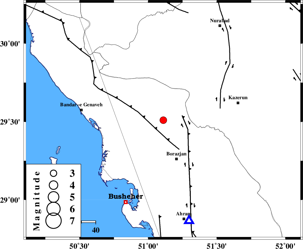
| Location | Lat:29.51 Lon: 51.11 |
| Region | Bushehr Province, 29 km North of Borazjan |
Nearest Cities |
|
| 12 km North East of Dehkohneh, Bushehr Province | |
| 15 km North of Saedabad, Bushehr Province | |
| 17 km North of Nazar aqa, Bushehr Province | |
| 20 km North West of Dalki, Bushehr Province | |
| 23 km West of Khesht, Fars Province | |
| Depth | 14 km |
| Agency | |
Faults within 150 km: |
|
| ZFF3 (Length: 125 km) , Distance to epicenter: 8 km | |
| BORAZJAN_F (Length: 168 km) , Distance to epicenter: 14 km | |
| KAZERUN_F (Length: 96 km) , Distance to epicenter: 41 km | |
| Number of Phases | 5 |
| RMS | 0.2 |
| Number of Stations | 4 |
| Error in Latitude | >4 km |
| Error in Longitude | 4.5 km |
| Error in Depth | 9.2 km |
Download waveform in seisan format
to download seisan software Click here
to access information about IIEES stations Click here
Amplitude | ||||||||
| UID | Agency | Station | Component | Amplitude | Period | Arrival Time | Proccessing Time | Signal Clip |
| 86645 | IIEES | GHIR | E | 190.1 | 0.56 | 2012-10-18 16:14:25 | 2012-10-18 05:01:00 | n |
| 86646 | IIEES | KRBR | E | 21.1 | 0.48 | 2012-10-18 16:15:27 | 2012-10-18 05:01:00 | n |
Phase | ||||||||||||
| Agency | Station | Component | Phase Type | Phase Quality | First Motion | Observed Arrival Time | Time Residual | Loc. Flag | Input Weight | Distance | Azimuth | |
| IIEES | AHRM | Z | Pg | E | 2012-10-18 16:13:19 | -0.03 | y | 73.4 | 165 | |||
| IIEES | AHRM | N | Sg | E | 2012-10-18 16:13:29 | -0.09 | y | 73.4 | 165 | |||
| IIEES | GHIR | Z | Pn | E | 2012-10-18 16:13:43 | 0.33 | y | 228 | 126 | |||
| IIEES | GHIR | E | Sg | E | 2012-10-18 16:14:11 | -0.05 | y | 228 | 126 | |||
| IIEES | YZKH | Z | Pn | E | 2012-10-18 16:14:12 | -0.22 | y | 461 | 45 | |||