
Magnitude |
:3.6 |
| Date & Time (UTC) | 2012-10-18 01:35:47.0 |
| Date & Time (Local) | 1391/7/27 05:05:47.0 |
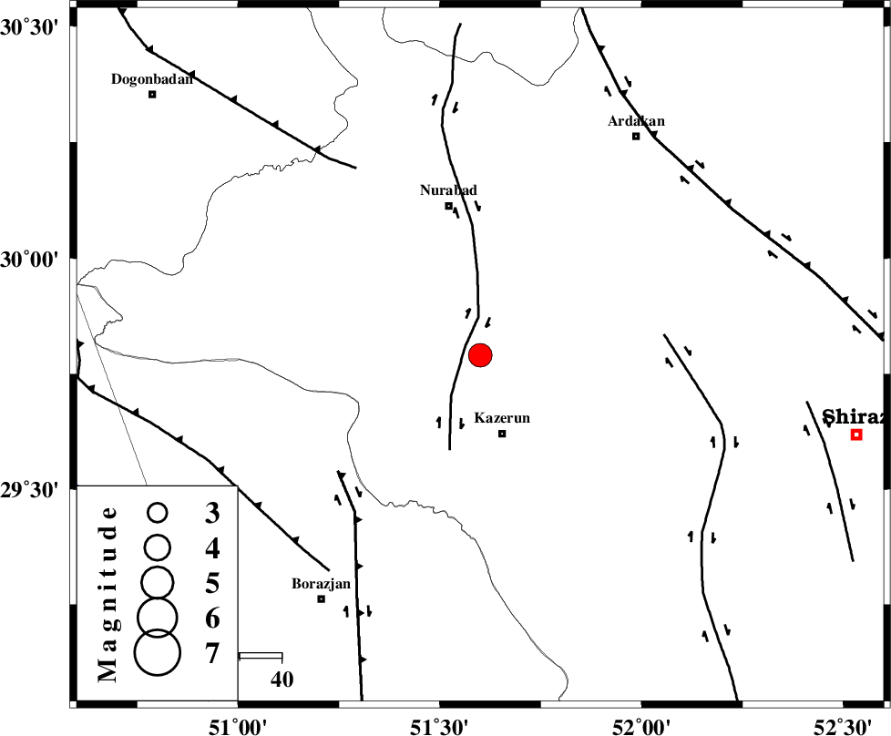
| Location | Lat:29.79 Lon: 51.6 |
| Region | Fars Province, 19 km North of Kazerun |
Nearest Cities |
|
| 3 km of Seyyed hasan, Fars Province | |
| 10 km West of Nodan, Fars Province | |
| 13 km North of Deris, Fars Province | |
| 20 km North of Kazerun, Fars Province | |
| 21 km North East of Kamaraj, Fars Province | |
| Depth | 14 km |
| Agency | |
Faults within 150 km: |
|
| KAZERUN_F (Length: 96 km) , Distance to epicenter: 4 km | |
| BORAZJAN_F (Length: 168 km) , Distance to epicenter: 44 km | |
| KAREBASS_F (Length: 98 km) , Distance to epicenter: 44 km | |
| Number of Phases | 7 |
| RMS | 0.1 |
| Number of Stations | 5 |
| Error in Latitude | >2.2 km |
| Error in Longitude | 1.7 km |
| Error in Depth | 5.6 km |
Download waveform in seisan format
to download seisan software Click here
to access information about IIEES stations Click here
Amplitude | ||||||||
| UID | Agency | Station | Component | Amplitude | Period | Arrival Time | Proccessing Time | Signal Clip |
| 86634 | IIEES | GHIR | E | 347 | 0.52 | 2012-10-18 01:37:10 | 2012-10-18 01:53:00 | n |
| 86635 | IIEES | SHGR | E | 176.5 | 0.48 | 2012-10-18 01:37:46 | 2012-10-18 01:53:00 | n |
| 86636 | IIEES | SHGR | N | 158.5 | 0.6 | 2012-10-18 01:37:54 | 2012-10-18 01:53:00 | n |
| 86637 | IIEES | KRBR | N | 56.7 | 0.6 | 2012-10-18 01:37:56 | 2012-10-18 01:53:00 | n |
Phase | ||||||||||||
| Agency | Station | Component | Phase Type | Phase Quality | First Motion | Observed Arrival Time | Time Residual | Loc. Flag | Input Weight | Distance | Azimuth | |
| IIEES | AHRM | Z | Pg | E | 2012-10-18 01:36:04 | -0.1 | y | 106 | 196 | |||
| IIEES | AHRM | E | Sg | E | 2012-10-18 01:36:17 | 0.03 | y | 106 | 196 | |||
| IIEES | GHIR | Z | Pn | E | 2012-10-18 01:36:21 | 0.03 | y | 214 | 141 | |||
| IIEES | GHIR | E | Sg | E | 2012-10-18 01:36:47 | 0.03 | y | 214 | 141 | |||
| IIEES | SHGR | Z | Pn | E | 2012-10-18 01:36:40 | 0.13 | y | 371 | 315 | |||
| IIEES | KRBR | Z | Pn | E | 2012-10-18 01:36:56 | -0.05 | y | 499 | 86 | |||
| IIEES | SNGE | Z | Pn | E | 2012-10-18 01:37:23 | -0.15 | y | 711 | 327 | |||