
Magnitude |
:3.2 |
| Date & Time (UTC) | 2012-10-07 16:42:19.7 |
| Date & Time (Local) | 1391/7/16 20:12:19.7 |
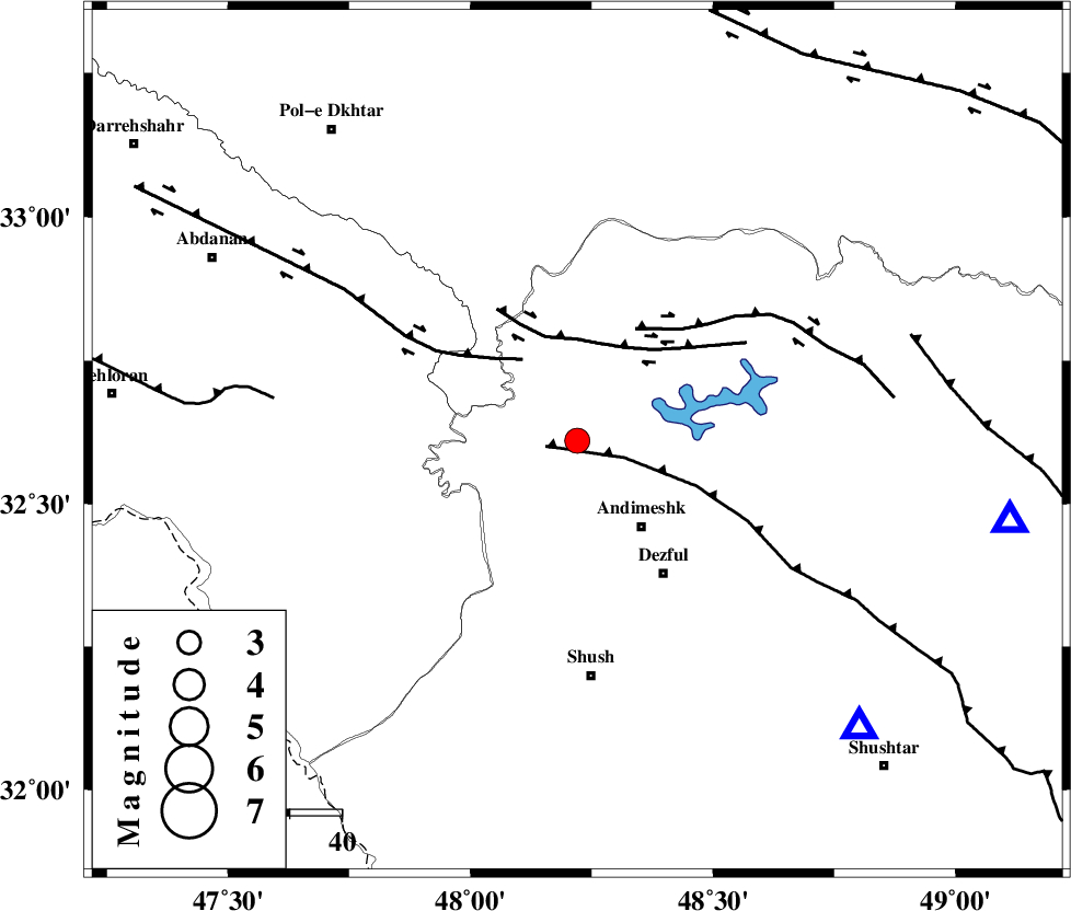
| Location | Lat:32.61 Lon: 48.22 |
| Region | Khoozestan Province, 21 km North-West of Andimeshk |
Nearest Cities |
|
| 8 km of Hoseinieh, Khoozestan Province | |
| 16 km South of Bidruyeh, Khoozestan Province | |
| 21 km North West of Andimeshk, Khoozestan Province | |
| 21 km South West of Sorkhakan, Khoozestan Province | |
| 31 km North West of Dezful, Khoozestan Province | |
| Depth | 14 km |
| Agency | |
Faults within 150 km: |
|
| DEZFUL_EMBAYMENT (Length: 228 km) , Distance to epicenter: 6 km | |
| BALARUD_F_Z1 (Length: 87 km) , Distance to epicenter: 19 km | |
| BALARUD_F_Z3 (Length: 53 km) , Distance to epicenter: 19 km | |
| Number of Phases | 5 |
| RMS | 0.1 |
| Number of Stations | 4 |
| Error in Latitude | >1.5 km |
| Error in Longitude | 4.1 km |
| Error in Depth | 4.8 km |
Download waveform in seisan format
to download seisan software Click here
to access information about IIEES stations Click here
Amplitude | ||||||||
| UID | Agency | Station | Component | Amplitude | Period | Arrival Time | Proccessing Time | Signal Clip |
| 86440 | IIEES | SHGR | E | 977.7 | 0.44 | 2012-10-07 16:42:53 | 2012-10-07 05:04:00 | n |
| 86441 | IIEES | SHGR | N | 873.1 | 0.52 | 2012-10-07 16:43:01 | 2012-10-07 05:04:00 | n |
| 86442 | IIEES | ASAO | E | 106.9 | 0.48 | 2012-10-07 16:43:42 | 2012-10-07 05:04:00 | n |
| 86443 | IIEES | SNGE | E | 113.3 | 0.68 | 2012-10-07 16:43:47 | 2012-10-07 05:04:00 | n |
| 86444 | IIEES | SNGE | N | 106 | 0.52 | 2012-10-07 16:43:50 | 2012-10-07 05:04:00 | n |
| 86445 | IIEES | GHVR | N | 52.5 | 0.56 | 2012-10-07 16:44:05 | 2012-10-07 05:04:00 | n |
| 86446 | IIEES | GHVR | E | 50.6 | 0.6 | 2012-10-07 16:44:08 | 2012-10-07 05:04:00 | n |
Phase | ||||||||||||
| Agency | Station | Component | Phase Type | Phase Quality | First Motion | Observed Arrival Time | Time Residual | Loc. Flag | Input Weight | Distance | Azimuth | |
| IIEES | SHGR | Z | Pg | E | 2012-10-07 16:42:33 | -0.01 | y | 78 | 135 | |||
| IIEES | ASAO | Z | Pn | E | 2012-10-07 16:43:01 | 0.12 | y | 273 | 37 | |||
| IIEES | ASAO | E | Sg | E | 2012-10-07 16:43:36 | -0.03 | y | 273 | 37 | |||
| IIEES | SNGE | Z | Pn | E | 2012-10-07 16:43:03 | -0.04 | y | 287 | 344 | |||
| IIEES | GHVR | Z | Pn | E | 2012-10-07 16:43:10 | -0.05 | y | 349 | 53 | |||