
Magnitude |
:2.5 |
| Date & Time (UTC) | 2012-10-07 16:01:23.9 |
| Date & Time (Local) | 1391/7/16 19:31:23.9 |
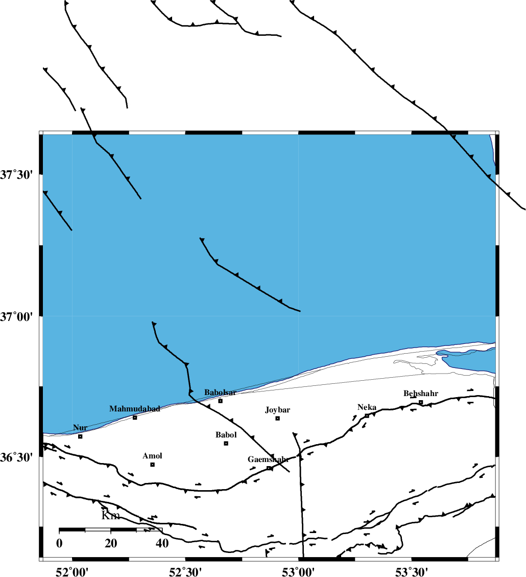
| Location | Lat:36.89 Lon: 52.87 |
| Region | Caspian Sea, 29 km North of Joybar |
Nearest Cities |
|
| 19 km North of Larim, Mazandaran Province | |
| 24 km North of Kuhikhel, Mazandaran Province | |
| 24 km North West of Farahabad, Mazandaran Province | |
| 25 km North of Bahmonir, Mazandaran Province | |
| 28 km North of Joybar, Mazandaran Province | |
| Depth | 14 km |
| Agency | |
Faults within 150 km: |
|
| KHAZAR_F (Length: 523 km) , Distance to epicenter: 44 km | |
| N_ALBORZ_F (Length: 360 km) , Distance to epicenter: 77 km | |
| KOJOOR (Length: 75 km) , Distance to epicenter: 119 km | |
| Number of Phases | 6 |
| RMS | 0.2 |
| Number of Stations | 4 |
| Error in Latitude | >3.8 km |
| Error in Longitude | 3.5 km |
| Error in Depth | 7.3 km |
Download waveform in seisan format
to download seisan software Click here
to access information about IIEES stations Click here
Amplitude | ||||||||
| UID | Agency | Station | Component | Amplitude | Period | Arrival Time | Proccessing Time | Signal Clip |
| 86438 | IIEES | GHVR | E | 21.5 | 0.72 | 2012-10-07 16:02:51 | 2012-10-07 05:04:00 | n |
| 86439 | IIEES | GHVR | N | 15.5 | 0.52 | 2012-10-07 16:02:51 | 2012-10-07 05:04:00 | n |
Phase | ||||||||||||
| Agency | Station | Component | Phase Type | Phase Quality | First Motion | Observed Arrival Time | Time Residual | Loc. Flag | Input Weight | Distance | Azimuth | |
| IIEES | THKV | Z | P | E | 2012-10-07 16:01:57 | -0.12 | y | 209 | 239 | |||
| IIEES | MRVT | Z | Pn | E | 2012-10-07 16:02:08 | -0.09 | y | 298 | 72 | |||
| IIEES | SHRO | Z | Pn | E | 2012-10-07 16:02:09 | 0.39 | y | 298 | 108 | |||
| IIEES | SHRO | N | Sg | E | 2012-10-07 16:02:47 | -0.18 | y | 298 | 108 | |||
| IIEES | GHVR | Z | Pn | E | 2012-10-07 16:02:09 | -0.04 | y | 305 | 209 | |||
| IIEES | GHVR | N | S | E | 2012-10-07 16:02:42 | 0.05 | y | 305 | 209 | |||