
Magnitude |
:3.5 |
| Date & Time (UTC) | 2012-10-07 04:50:53.9 |
| Date & Time (Local) | 1391/7/16 08:20:53.9 |
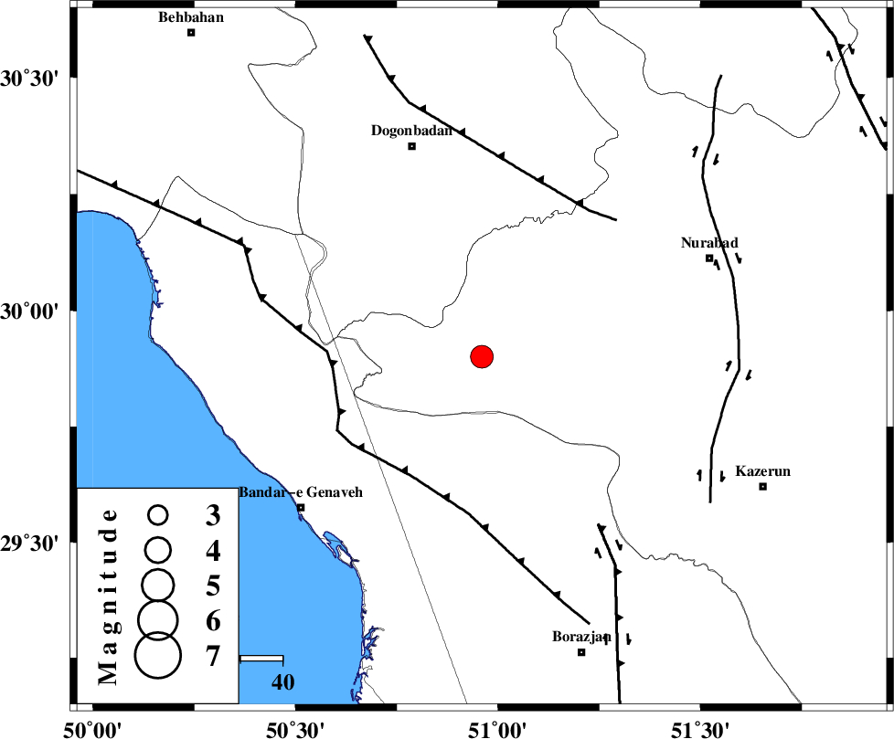
| Location | Lat:29.9 Lon: 50.96 |
| Region | Fars Province, 53 km South-East of Dogonbadan |
Nearest Cities |
|
| 30 km South West of Babamonir, Fars Province | |
| 43 km North East of Chehar rustaee, Bushehr Province | |
| 44 km North East of Mohammad salehi, Bushehr Province | |
| 47 km North of Dehkohneh, Bushehr Province | |
| 51 km South West of Ahangari, Fars Province | |
| Depth | 46 km |
| Agency | |
Faults within 150 km: |
|
| ZFF3 (Length: 125 km) , Distance to epicenter: 33 km | |
| MISHAN_F (Length: 76 km) , Distance to epicenter: 43 km | |
| BORAZJAN_F (Length: 168 km) , Distance to epicenter: 49 km | |
| Number of Phases | 8 |
| RMS | 0.3 |
| Number of Stations | 7 |
| Error in Latitude | >4.6 km |
| Error in Longitude | 6.1 km |
| Error in Depth | 8.2 km |
Download waveform in seisan format
to download seisan software Click here
to access information about IIEES stations Click here
Amplitude | ||||||||
| UID | Agency | Station | Component | Amplitude | Period | Arrival Time | Proccessing Time | Signal Clip |
| 86427 | IIEES | AHRM | N | 1149.7 | 0.51 | 2012-10-07 04:51:31 | 2012-10-07 05:13:00 | n |
| 86428 | IIEES | AHRM | E | 1172.4 | 0.51 | 2012-10-07 04:51:34 | 2012-10-07 05:13:00 | n |
| 86429 | IIEES | GHIR | E | 203.1 | 0.43 | 2012-10-07 04:52:21 | 2012-10-07 05:13:00 | n |
Phase | ||||||||||||
| Agency | Station | Component | Phase Type | Phase Quality | First Motion | Observed Arrival Time | Time Residual | Loc. Flag | Input Weight | Distance | Azimuth | |
| IIEES | AHRM | Z | Pg | E | 2012-10-07 04:51:13 | -0.45 | y | 119 | 164 | |||
| IIEES | AHRM | N | Sg | E | 2012-10-07 04:51:29 | 0.37 | y | 119 | 164 | |||
| IIEES | GHIR | Z | Pn | E | 2012-10-07 04:51:31 | -0.14 | y | 266 | 132 | |||
| IIEES | SHGR | Z | Pn | E | 2012-10-07 04:51:38 | 0.11 | y | 320 | 320 | |||
| IIEES | NASN | Z | Pn | E | 2012-10-07 04:51:44 | -0.01 | y | 366 | 28 | |||
| IIEES | YZKH | Z | P | E | 2012-10-07 04:51:54 | 0.3 | y | 443 | 50 | |||
| IIEES | GHVR | Z | Pn | E | 2012-10-07 04:52:01 | -0.01 | y | 509 | 3 | |||
| IIEES | TABS | Z | Pn | E | 2012-10-07 04:52:27 | -0.2 | y | 716 | 53 | |||