
Magnitude |
:2.4 |
| Date & Time (UTC) | 2012-09-30 04:35:06.1 |
| Date & Time (Local) | 1391/7/9 08:05:06.1 |
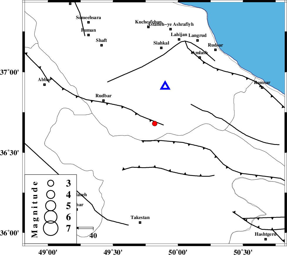
| Location | Lat:36.68 Lon: 49.82 |
| Region | Gilan Province, 52 km South of Siahkal |
Nearest Cities |
|
| 4 km of Jirhandeh, Gilan Province | |
| 15 km West of Kelishom, Gilan Province | |
| 21 km South of Barresar, Gilan Province | |
| 24 km South East of Dashtvil, Gilan Province | |
| 28 km North East of Kuhgir-e sofla, Ghazvin Province | |
| Depth | 15 km |
| Agency | |
Faults within 150 km: |
|
| RUDBAR_F (Length: 93 km) , Distance to epicenter: 6 km | |
| ALAMUTRUD_F (Length: 140 km) , Distance to epicenter: 13 km | |
| BONAN_F (Length: 74 km) , Distance to epicenter: 28 km | |
| Number of Phases | 6 |
| RMS | 0.2 |
| Number of Stations | 5 |
| Error in Latitude | >3.1 km |
| Error in Longitude | 4.6 km |
| Error in Depth | 7.5 km |
Download waveform in seisan format
to download seisan software Click here
to access information about IIEES stations Click here
Amplitude | ||||||||
| UID | Agency | Station | Component | Amplitude | Period | Arrival Time | Proccessing Time | Signal Clip |
| 86351 | IIEES | ZNJK | N | 106.9 | 0.16 | 2012-09-30 04:35:37 | 2012-09-30 05:11:00 | n |
Phase | ||||||||||||
| Agency | Station | Component | Phase Type | Phase Quality | First Motion | Observed Arrival Time | Time Residual | Loc. Flag | Input Weight | Distance | Azimuth | |
| IIEES | ZNJK | Z | Pg | E | 2012-09-30 04:35:23 | -0.13 | y | 101 | 270 | |||
| IIEES | ZNJK | E | Sg | E | 2012-09-30 04:35:36 | 0.13 | y | 101 | 270 | |||
| IIEES | ASAO | Z | Pn | E | 2012-09-30 04:35:43 | 0.23 | y | 237 | 175 | |||
| IIEES | GHVR | Z | Pn | E | 2012-09-30 04:35:47 | -0.07 | y | 276 | 152 | |||
| IIEES | SNGE | Z | Pn | E | 2012-09-30 04:35:48 | -0.22 | y | 284 | 232 | |||
| IIEES | GRMI | Z | Pn | E | 2012-09-30 04:35:49 | 0.05 | y | 291 | 325 | |||