
Magnitude |
:2.6 |
| Date & Time (UTC) | 2012-09-19 03:31:02.2 |
| Date & Time (Local) | 1391/6/29 08:01:02.2 |
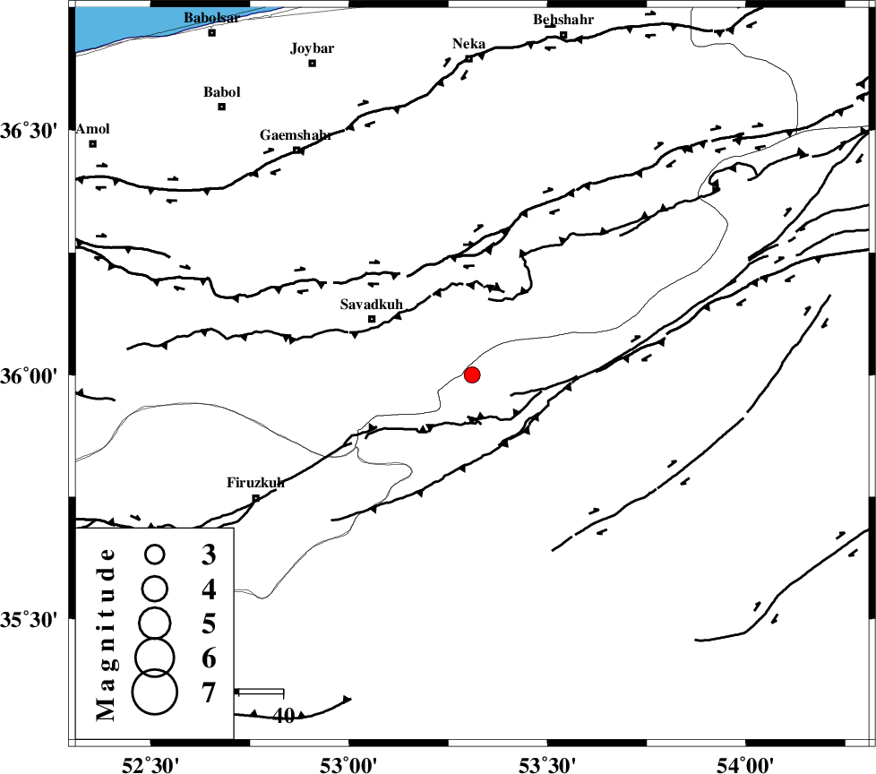
| Location | Lat:36 Lon: 53.31 |
| Region | Semnan Province, 26 km South-East of Pol-E-Sefid |
Nearest Cities |
|
| 11 km of Sangdeh, Mazandaran Province | |
| 13 km North of Chashem, Semnan Province | |
| 25 km East of Shurmast-e peyrudbar, Mazandaran Province | |
| 26 km South East of Pol-E-Sefid, Mazandaran Province | |
| 26 km North of Shahmirzad, Semnan Province | |
| Depth | 15 km |
| Agency | |
Faults within 150 km: |
|
| N_ALBORZ_F (Length: 360 km) , Distance to epicenter: 26 km | |
| ATARI_F (Length: 185 km) , Distance to epicenter: 32 km | |
| DAMGHAN_F (Length: 95 km) , Distance to epicenter: 50 km | |
| Number of Phases | 6 |
| RMS | 0.1 |
| Number of Stations | 5 |
| Error in Latitude | >5.4 km |
| Error in Longitude | 2.7 km |
| Error in Depth | 9.7 km |
Download waveform in seisan format
to download seisan software Click here
to access information about IIEES stations Click here
Amplitude | ||||||||
| UID | Agency | Station | Component | Amplitude | Period | Arrival Time | Proccessing Time | Signal Clip |
| 86208 | IIEES | GHVR | E | 38.9 | 0.33 | 2012-09-19 03:32:20 | 2012-09-19 03:57:00 | n |
Phase | ||||||||||||
| Agency | Station | Component | Phase Type | Phase Quality | First Motion | Observed Arrival Time | Time Residual | Loc. Flag | Input Weight | Distance | Azimuth | |
| IIEES | THKV | Z | Pn | E | 2012-09-19 03:31:37 | -0.22 | y | 219 | 268 | |||
| IIEES | SHRO | Z | Pn | E | 2012-09-19 03:31:40 | -0.01 | y | 244 | 89 | |||
| IIEES | GHVR | Z | Pn | E | 2012-09-19 03:31:41 | 0.11 | y | 252 | 229 | |||
| IIEES | GHVR | N | Sg | E | 2012-09-19 03:32:13 | 0 | y | 252 | 229 | |||
| IIEES | ASAO | Z | Pn | E | 2012-09-19 03:31:52 | -0.06 | y | 339 | 243 | |||
| IIEES | ZNJK | Z | Pn | E | 2012-09-19 03:32:02 | 0.24 | y | 422 | 282 | |||