
Magnitude |
:1.6 |
| Date & Time (UTC) | 2012-09-18 02:41:51.8 |
| Date & Time (Local) | 1391/6/28 07:11:51.8 |
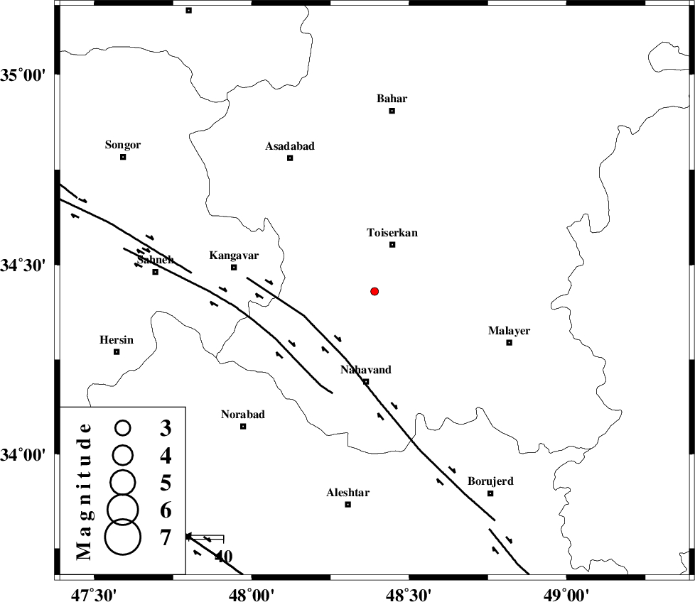
| Location | Lat:34.43 Lon: 48.39 |
| Region | Hamedan Province, 15 km South of Tuyserkan |
Nearest Cities |
|
| 5 km North of Miyandeh, Hamedan Province | |
| 11 km East of Farsang, Hamedan Province | |
| 12 km West of Seyyed shahab, Hamedan Province | |
| 12 km South of Jaefaryeh, Hamedan Province | |
| 15 km South of Tuyserkan, Hamedan Province | |
| Depth | 38 km |
| Agency | |
Faults within 150 km: |
|
| NAHAVAND_F (Length: 102 km) , Distance to epicenter: 22 km | |
| SAHANEH_F (Length: 77 km) , Distance to epicenter: 31 km | |
| DINEHVAR_F (Length: 46 km) , Distance to epicenter: 54 km | |
| Number of Phases | 6 |
| RMS | 0.3 |
| Number of Stations | 3 |
| Error in Latitude | >7.4 km |
| Error in Longitude | 4.5 km |
| Error in Depth | 6.2 km |
Download waveform in seisan format
to download seisan software Click here
to access information about IIEES stations Click here
Amplitude | ||||||||
| UID | Agency | Station | Component | Amplitude | Period | Arrival Time | Proccessing Time | Signal Clip |
| 86191 | IIEES | SNGE | N | 20.8 | 0.2 | 2012-09-18 02:42:29 | 2012-09-18 04:02:00 | n |
| 86192 | IIEES | SNGE | E | 11.6 | 0.13 | 2012-09-18 02:42:30 | 2012-09-18 04:02:00 | n |
| 86193 | IIEES | ASAO | E | 8.7 | 0.36 | 2012-09-18 02:42:41 | 2012-09-18 04:02:00 | n |
| 86194 | IIEES | KHMZ | N | 7.6 | 0.36 | 2012-09-18 02:42:46 | 2012-09-18 04:02:00 | n |
| 86195 | IIEES | KHMZ | E | 8.5 | 0.28 | 2012-09-18 02:42:47 | 2012-09-18 04:02:00 | n |
Phase | ||||||||||||
| Agency | Station | Component | Phase Type | Phase Quality | First Motion | Observed Arrival Time | Time Residual | Loc. Flag | Input Weight | Distance | Azimuth | |
| IIEES | SNGE | Z | Pg | E | 2012-09-18 02:42:12 | -0.13 | y | 121 | 308 | |||
| IIEES | SNGE | N | Sg | E | 2012-09-18 02:42:27 | 0.1 | y | 121 | 308 | |||
| IIEES | ASAO | E | Pn | E | 2012-09-18 02:42:16 | 0.53 | y | 151 | 85 | |||
| IIEES | ASAO | E | Sg | E | 2012-09-18 02:42:34 | -0.26 | y | 151 | 85 | |||
| IIEES | KHMZ | N | Pn | E | 2012-09-18 02:42:17 | -0.52 | y | 164 | 117 | |||
| IIEES | KHMZ | E | Sg | E | 2012-09-18 02:42:38 | 0.28 | y | 164 | 117 | |||