
Magnitude |
:2.6 |
| Date & Time (UTC) | 2012-09-15 02:30:06.1 |
| Date & Time (Local) | 1391/6/25 07:00:06.1 |
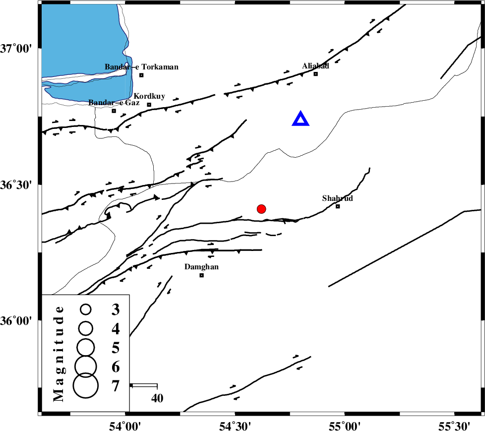
| Location | Lat:36.41 Lon: 54.62 |
| Region | Semnan Province, 32 km West of Shahrud |
Nearest Cities |
|
| 8 km of Majen, Semnan Province | |
| 22 km South East of Cheharbagh, Golestan Province | |
| 22 km North of Mehmandust, Semnan Province | |
| 31 km West of Shahrud, Semnan Province | |
| 33 km South East of Naharkhoran, Golestan Province | |
| Depth | 14 km |
| Agency | |
Faults within 150 km: |
|
| ASTANEH_F (Length: 72 km) , Distance to epicenter: 8 km | |
| ATARI_F (Length: 185 km) , Distance to epicenter: 17 km | |
| DAMGHAN_F (Length: 95 km) , Distance to epicenter: 18 km | |
| Number of Phases | 5 |
| RMS | 0.1 |
| Number of Stations | 4 |
| Error in Latitude | >1.9 km |
| Error in Longitude | 6.6 km |
| Error in Depth | 6.5 km |
Download waveform in seisan format
to download seisan software Click here
to access information about IIEES stations Click here
Amplitude | ||||||||
| UID | Agency | Station | Component | Amplitude | Period | Arrival Time | Proccessing Time | Signal Clip |
| 86131 | IIEES | SHRO | N | 121 | 0.36 | 2012-09-15 02:30:47 | 2012-09-15 03:00:00 | n |
| 86132 | IIEES | MRVT | E | 63.9 | 0.24 | 2012-09-15 02:31:03 | 2012-09-15 03:00:00 | n |
| 86133 | IIEES | MRVT | N | 49.6 | 0.24 | 2012-09-15 02:31:03 | 2012-09-15 03:00:00 | n |
| 86134 | IIEES | GHVR | N | 14.1 | 0.44 | 2012-09-15 02:31:59 | 2012-09-15 03:00:00 | n |
| 86135 | IIEES | GHVR | E | 27.3 | 0.32 | 2012-09-15 02:32:04 | 2012-09-15 03:00:00 | n |
Phase | ||||||||||||
| Agency | Station | Component | Phase Type | Phase Quality | First Motion | Observed Arrival Time | Time Residual | Loc. Flag | Input Weight | Distance | Azimuth | |
| IIEES | SHRO | Z | Pg | E | 2012-09-15 02:30:28 | -0.03 | y | 133 | 109 | |||
| IIEES | SHRO | E | Sg | E | 2012-09-15 02:30:44 | 0.04 | y | 133 | 109 | |||
| IIEES | MRVT | Z | Pn | E | 2012-09-15 02:30:37 | 0.16 | y | 191 | 43 | |||
| IIEES | MRVT | E | Sg | E | 2012-09-15 02:31:00 | -0.01 | y | 191 | 43 | |||
| IIEES | BJRD | N | Pn | E | 2012-09-15 02:30:49 | -0.17 | y | 287 | 59 | |||