
Magnitude |
:2.8 |
| Date & Time (UTC) | 2012-09-13 07:01:05.7 |
| Date & Time (Local) | 1391/6/23 11:31:05.7 |
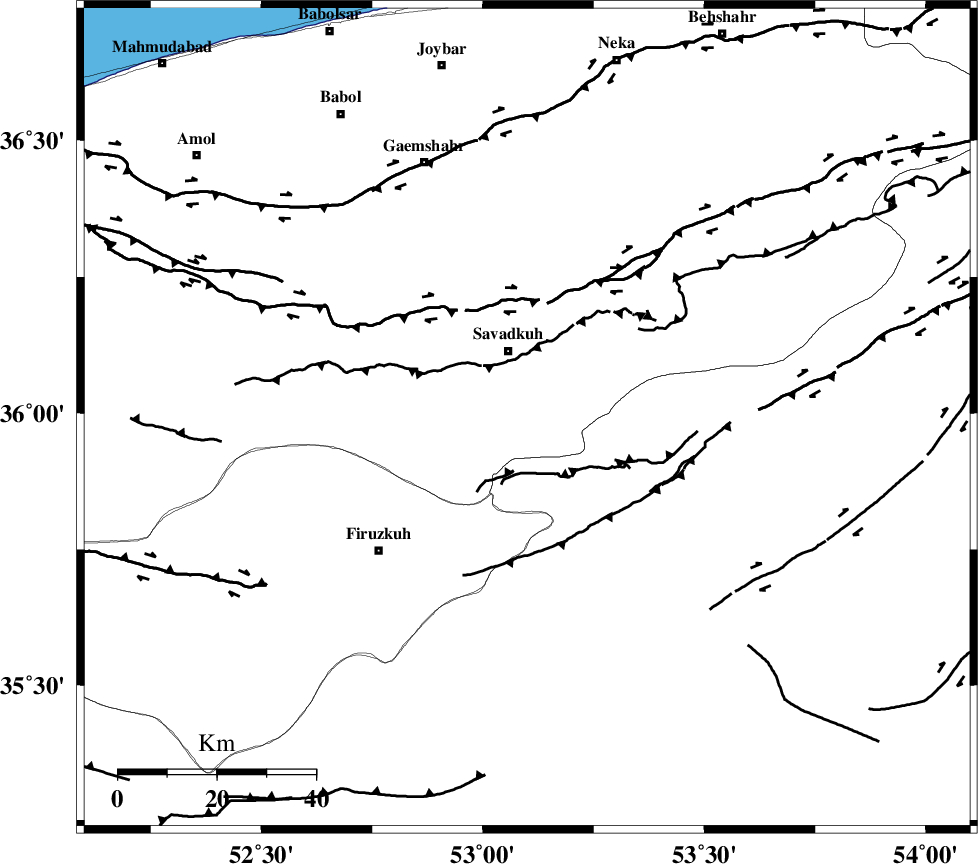
| Location | Lat:35.99 Lon: 53.1 |
| Region | Mazandaran Province, 14 km South of Pol-E-Sefid |
Nearest Cities |
|
| 12 km South of Shurmast-e peyrudbar, Mazandaran Province | |
| 14 km South of Pol-E-Sefid, Mazandaran Province | |
| 14 km West of Sangdeh, Mazandaran Province | |
| 16 km South East of Elahband, Mazandaran Province | |
| 18 km North West of Chashem, Semnan Province | |
| Depth | 14 km |
| Agency | |
Faults within 150 km: |
|
| N_ALBORZ_F (Length: 360 km) , Distance to epicenter: 24 km | |
| ATARI_F (Length: 185 km) , Distance to epicenter: 32 km | |
| MOSHA_F (Length: 234 km) , Distance to epicenter: 53 km | |
| Number of Phases | 6 |
| RMS | 0.2 |
| Number of Stations | 5 |
| Error in Latitude | >4.8 km |
| Error in Longitude | 5.4 km |
| Error in Depth | 8.4 km |
Download waveform in seisan format
to download seisan software Click here
to access information about IIEES stations Click here
Amplitude | ||||||||
| UID | Agency | Station | Component | Amplitude | Period | Arrival Time | Proccessing Time | Signal Clip |
| 86107 | IIEES | GHVR | N | 36.4 | 0.55 | 2012-09-13 07:02:19 | 2012-09-13 07:35:00 | n |
| 86108 | IIEES | GHVR | E | 100 | 0.49 | 2012-09-13 07:02:20 | 2012-09-13 07:35:00 | n |
| 86109 | IIEES | ASAO | E | 26.5 | 0.65 | 2012-09-13 07:02:37 | 2012-09-13 07:35:00 | n |
Phase | ||||||||||||
| Agency | Station | Component | Phase Type | Phase Quality | First Motion | Observed Arrival Time | Time Residual | Loc. Flag | Input Weight | Distance | Azimuth | |
| IIEES | CHTH | Z | Pg | E | 2012-09-13 07:01:34 | -0.45 | y | 178 | 268 | |||
| IIEES | THKV | Z | Pg | E | 2012-09-13 07:01:39 | 0.38 | y | 201 | 268 | |||
| IIEES | GHVR | Z | Pn | E | 2012-09-13 07:01:43 | 0.1 | y | 238 | 226 | |||
| IIEES | GHVR | E | Sg | E | 2012-09-13 07:02:13 | -0.07 | y | 238 | 226 | |||
| IIEES | SHRO | Z | Pn | E | 2012-09-13 07:01:46 | -0.05 | y | 263 | 89 | |||
| IIEES | ASAO | Z | Pn | E | 2012-09-13 07:01:53 | 0.1 | y | 322 | 241 | |||