
Magnitude |
:2.9 |
| Date & Time (UTC) | 2012-09-09 16:37:10.9 |
| Date & Time (Local) | 1391/6/19 21:07:10.9 |
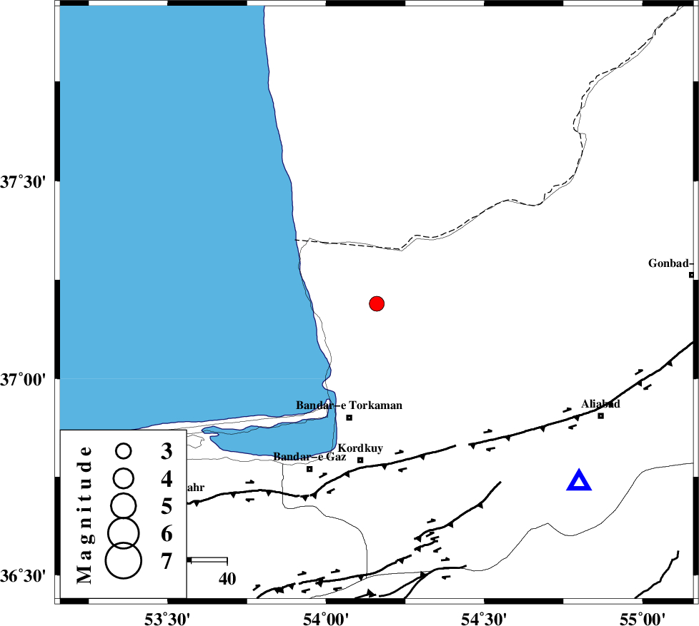
| Location | Lat:37.19 Lon: 54.16 |
| Region | Golestan Province, 33 km North of Bandar-e torkaman |
Nearest Cities |
|
| 12 km North of Gomishtappeh, Golestan Province | |
| 21 km North of Banavar, Golestan Province | |
| 33 km North West of Aq Qaleh, Golestan Province | |
| 33 km North of Bandar-e torkaman, Golestan Province | |
| 35 km North of Sijval, Golestan Province | |
| Depth | 16 km |
| Agency | |
Faults within 150 km: |
|
| KHAZAR_F (Length: 523 km) , Distance to epicenter: 43 km | |
| N_ALBORZ_F (Length: 360 km) , Distance to epicenter: 68 km | |
| SHAVAR_F (Length: 87 km) , Distance to epicenter: 73 km | |
| Number of Phases | 8 |
| RMS | 0.1 |
| Number of Stations | 6 |
| Error in Latitude | >2.4 km |
| Error in Longitude | 1.3 km |
| Error in Depth | 3.1 km |
Download waveform in seisan format
to download seisan software Click here
to access information about IIEES stations Click here
Amplitude | ||||||||
| UID | Agency | Station | Component | Amplitude | Period | Arrival Time | Proccessing Time | Signal Clip |
| 86062 | IIEES | DAMV | E | 64.3 | 0.6 | 2012-09-09 16:38:26 | 2012-09-09 09:48:00 | n |
| 86063 | IIEES | GHVR | E | 18.8 | 0.6 | 2012-09-09 16:39:11 | 2012-09-09 09:48:00 | n |
Phase | ||||||||||||
| Agency | Station | Component | Phase Type | Phase Quality | First Motion | Observed Arrival Time | Time Residual | Loc. Flag | Input Weight | Distance | Azimuth | |
| IIEES | MRVT | Z | Pg | E | 2012-09-09 16:37:40 | 0.01 | y | 179 | 73 | |||
| IIEES | SHRO | Z | Pn | E | 2012-09-09 16:37:44 | -0.23 | y | 212 | 128 | |||
| IIEES | SHRO | N | Sg | E | 2012-09-09 16:38:11 | 0.09 | y | 212 | 128 | |||
| IIEES | DAMV | Z | Pn | E | 2012-09-09 16:37:51 | 0.14 | y | 262 | 229 | |||
| IIEES | CHTH | Z | Pn | E | 2012-09-09 16:37:56 | 0.1 | y | 307 | 243 | |||
| IIEES | CHTH | E | Sg | E | 2012-09-09 16:38:37 | -0.11 | y | 307 | 243 | |||
| IIEES | THKV | Z | Pn | E | 2012-09-09 16:37:59 | 0.02 | y | 326 | 245 | |||
| IIEES | GHVR | Z | Pn | E | 2012-09-09 16:38:08 | -0.02 | y | 400 | 222 | |||