
Magnitude |
:3.5 |
| Date & Time (UTC) | 2012-09-07 12:59:32.8 |
| Date & Time (Local) | 1391/6/17 17:29:32.8 |
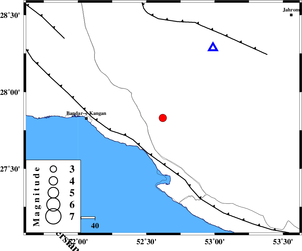
| Location | Lat:27.83 Lon: 52.62 |
| Region | Fars Province, 30 km East of Jam |
Nearest Cities |
|
| 12 km North of Asir, Fars Province | |
| 20 km North of Gallehdar, Fars Province | |
| 22 km South West of Garmesht, Fars Province | |
| 30 km East of Jam, Bushehr Province | |
| 33 km North West of Ardavan-e olia, Fars Province | |
| Depth | 14 km |
| Agency | |
Faults within 150 km: |
|
| MFF3 (Length: 292 km) , Distance to epicenter: 27 km | |
| QIR_F (Length: 130 km) , Distance to epicenter: 70 km | |
| MFF5 (Length: 74 km) , Distance to epicenter: 91 km | |
| Number of Phases | 5 |
| RMS | 0.1 |
| Number of Stations | 3 |
| Error in Latitude | >3.3 km |
| Error in Longitude | 5.5 km |
| Error in Depth | 6.8 km |
Download waveform in seisan format
to download seisan software Click here
to access information about IIEES stations Click here
Amplitude | ||||||||
| UID | Agency | Station | Component | Amplitude | Period | Arrival Time | Proccessing Time | Signal Clip |
| 86007 | IIEES | GHIR | E | 2836.5 | 0.48 | 2012-09-07 12:59:56 | 2012-09-07 01:20:00 | n |
| 86008 | IIEES | BNDS | E | 117.6 | 0.4 | 2012-09-07 13:01:15 | 2012-09-07 01:20:00 | n |
Phase | ||||||||||||
| Agency | Station | Component | Phase Type | Phase Quality | First Motion | Observed Arrival Time | Time Residual | Loc. Flag | Input Weight | Distance | Azimuth | |
| IIEES | GHIR | Z | Pg | E | 2012-09-07 12:59:43 | -0.21 | y | 62.4 | 35 | |||
| IIEES | GHIR | E | Sg | E | 2012-09-07 12:59:52 | 0.09 | y | 62.4 | 35 | |||
| IIEES | BNDS | Z | Pn | E | 2012-09-07 13:00:24 | 0.08 | y | 354 | 97 | |||
| IIEES | BNDS | E | Sg | E | 2012-09-07 13:01:12 | -0.06 | y | 354 | 97 | |||
| IIEES | KRBR | Z | Pn | E | 2012-09-07 13:00:39 | 0.14 | y | 469 | 58 | |||