
Magnitude |
:2.8 |
| Date & Time (UTC) | 2012-09-03 12:14:51.1 |
| Date & Time (Local) | 1391/6/13 16:44:51.1 |
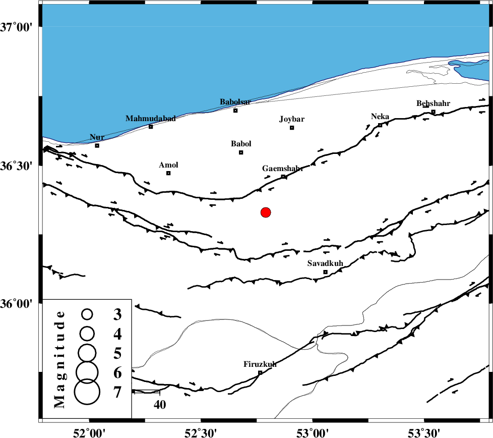
| Location | Lat:36.33 Lon: 52.79 |
| Region | Mazandaran Province, 16 km South of Qaemshahr |
Nearest Cities |
|
| 6 km North of Kij khalil, Mazandaran Province | |
| 6 km North of Derazkola, Mazandaran Province | |
| 10 km North West of Shirgah, Mazandaran Province | |
| 16 km South of Qaemshahr, Mazandaran Province | |
| 20 km South of Sangtab, Mazandaran Province | |
| Depth | 36 km |
| Agency | |
Faults within 150 km: |
|
| KHAZAR_F (Length: 523 km) , Distance to epicenter: 8 km | |
| N_ALBORZ_F (Length: 360 km) , Distance to epicenter: 16 km | |
| ATARI_F (Length: 185 km) , Distance to epicenter: 72 km | |
| Number of Phases | 6 |
| RMS | 0.2 |
| Number of Stations | 4 |
| Error in Latitude | >3.7 km |
| Error in Longitude | 4.9 km |
| Error in Depth | 6.8 km |
Download waveform in seisan format
to download seisan software Click here
to access information about IIEES stations Click here
Amplitude | ||||||||
| UID | Agency | Station | Component | Amplitude | Period | Arrival Time | Proccessing Time | Signal Clip |
| 85957 | IIEES | DAMV | E | 237.9 | 0.43 | 2012-09-03 12:15:23 | 2012-09-04 06:54:00 | n |
Phase | ||||||||||||
| Agency | Station | Component | Phase Type | Phase Quality | First Motion | Observed Arrival Time | Time Residual | Loc. Flag | Input Weight | Distance | Azimuth | |
| IIEES | DAMV | Z | Pg | E | 2012-09-03 12:15:09 | -0.29 | y | 107 | 224 | |||
| IIEES | CHTH | Z | Pg | E | 2012-09-03 12:15:16 | -0.1 | y | 157 | 253 | |||
| IIEES | CHTH | E | Sg | E | 2012-09-03 12:15:36 | 0.16 | y | 157 | 253 | |||
| IIEES | GHVR | Z | Pn | E | 2012-09-03 12:15:27 | -0.19 | y | 248 | 215 | |||
| IIEES | GHVR | N | Sg | E | 2012-09-03 12:16:00 | 0.24 | y | 248 | 215 | |||
| IIEES | MRVT | Z | Pn | E | 2012-09-03 12:15:37 | 0.2 | y | 329 | 62 | |||