
Magnitude |
:3.2 |
| Date & Time (UTC) | 2012-08-29 12:46:59.7 |
| Date & Time (Local) | 1391/6/8 17:16:59.7 |
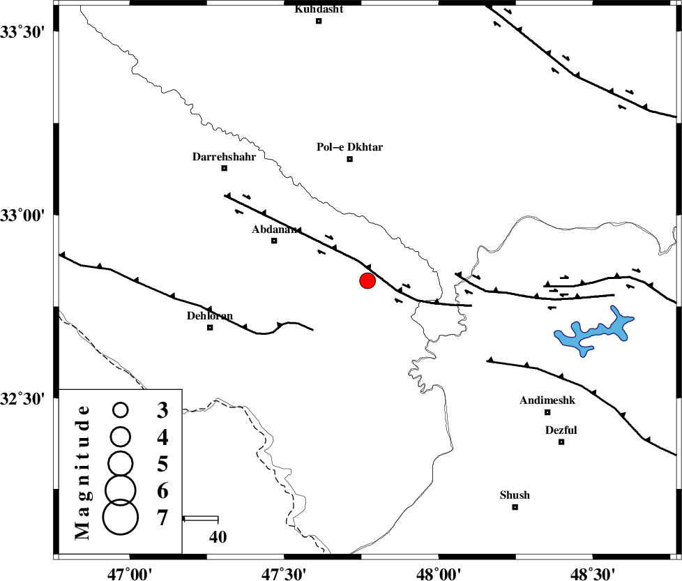
| Location | Lat:32.82 Lon: 47.77 |
| Region | Ilam Province, 38 km South of Pol-e dokhtar |
Nearest Cities |
|
| 21 km East of Sarabbagh, Ilam Province | |
| 31 km South East of Abdanan, Ilam Province | |
| 32 km South of Sarab hammam, Lorestan Province | |
| 37 km South of Pol-e dokhtar, Lorestan Province | |
| 44 km North West of Bidruyeh, Khoozestan Province | |
| Depth | 15 km |
| Agency | |
Faults within 150 km: |
|
| BALARUD_F_Z1 (Length: 87 km) , Distance to epicenter: 7 km | |
| MFF6 (Length: 144 km) , Distance to epicenter: 22 km | |
| BALARUD_F_Z3 (Length: 53 km) , Distance to epicenter: 27 km | |
| Number of Phases | 6 |
| RMS | 0.1 |
| Number of Stations | 5 |
| Error in Latitude | >2.3 km |
| Error in Longitude | 3.3 km |
| Error in Depth | 5 km |
Download waveform in seisan format
to download seisan software Click here
to access information about IIEES stations Click here
Amplitude | ||||||||
| UID | Agency | Station | Component | Amplitude | Period | Arrival Time | Proccessing Time | Signal Clip |
| 85855 | IIEES | SHGR | N | 499.9 | 0.24 | 2012-08-29 12:47:40 | 2012-08-29 01:04:00 | n |
| 85856 | IIEES | SHGR | E | 615.1 | 0.52 | 2012-08-29 12:47:41 | 2012-08-29 01:04:00 | n |
| 85857 | IIEES | KHMZ | N | 160.8 | 0.6 | 2012-08-29 12:48:15 | 2012-08-29 01:04:00 | n |
Phase | ||||||||||||
| Agency | Station | Component | Phase Type | Phase Quality | First Motion | Observed Arrival Time | Time Residual | Loc. Flag | Input Weight | Distance | Azimuth | |
| IIEES | SHGR | Z | Pg | E | 2012-08-29 12:47:20 | 0 | y | 125 | 129 | |||
| IIEES | KHMZ | Z | Pn | E | 2012-08-29 12:47:35 | -0.14 | y | 228 | 63 | |||
| IIEES | KHMZ | N | Sg | E | 2012-08-29 12:48:04 | 0 | y | 228 | 63 | |||
| IIEES | SNGE | Z | Pn | E | 2012-08-29 12:47:39 | -0.01 | y | 255 | 351 | |||
| IIEES | ASAO | Z | Pn | E | 2012-08-29 12:47:42 | 0.04 | y | 284 | 47 | |||
| IIEES | GHVR | Z | Pn | E | 2012-08-29 12:47:53 | 0.13 | y | 371 | 59 | |||