
Magnitude |
:3.8 |
| Date & Time (UTC) | 2012-08-25 08:36:35.6 |
| Date & Time (Local) | 1391/6/4 13:06:35.6 |
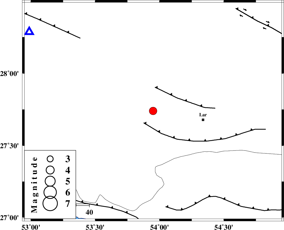
| Location | Lat:27.74 Lon: 53.95 |
| Region | Fars Province, 39 km West of Lar |
Nearest Cities |
|
| 7 km of Avaz, Fars Province | |
| 23 km North West of Grash, Fars Province | |
| 25 km South East of Kureh, Fars Province | |
| 27 km East of Fishur, Fars Province | |
| 28 km North of Bagh, Fars Province | |
| Depth | 6 km |
| Agency | |
Faults within 150 km: |
|
| LAR_F (Length: 99 km) , Distance to epicenter: 12 km | |
| BERIZ_F (Length: 49 km) , Distance to epicenter: 18 km | |
| MFF1 (Length: 180 km) , Distance to epicenter: 75 km | |
| Number of Phases | 5 |
| RMS | 0.1 |
| Number of Stations | 5 |
| Error in Latitude | >6.5 km |
| Error in Longitude | 5.6 km |
| Error in Depth | 8.3 km |
Download waveform in seisan format
to download seisan software Click here
to access information about IIEES stations Click here
Amplitude | ||||||||
| UID | Agency | Station | Component | Amplitude | Period | Arrival Time | Proccessing Time | Signal Clip |
| 85772 | IIEES | GHIR | E | 2473 | 0.47 | 2012-08-25 08:37:14 | 2012-08-25 09:10:00 | n |
| 85773 | IIEES | KHMZ | N | 12.5 | 0.59 | 2012-08-25 08:39:40 | 2012-08-25 09:10:00 | n |
| 85774 | IIEES | KHMZ | E | 19.5 | 0.49 | 2012-08-25 08:39:44 | 2012-08-25 09:10:00 | n |
| 85775 | IIEES | ASAO | E | 10.7 | 0.56 | 2012-08-25 08:40:03 | 2012-08-25 09:10:00 | n |
Phase | ||||||||||||
| Agency | Station | Component | Phase Type | Phase Quality | First Motion | Observed Arrival Time | Time Residual | Loc. Flag | Input Weight | Distance | Azimuth | |
| IIEES | GHIR | Z | Pg | E | 2012-08-25 08:36:55 | -0.08 | y | 112 | 303 | |||
| IIEES | BNDS | Z | Pn | E | 2012-08-25 08:37:11 | 0.03 | y | 222 | 99 | |||
| IIEES | KRBR | Z | Pn | E | 2012-08-25 08:37:30 | -0.09 | y | 370 | 47 | |||
| IIEES | KHMZ | Z | Pn | E | 2012-08-25 08:38:19 | 0.14 | y | 767 | 331 | |||
| IIEES | ASAO | Z | Pn | E | 2012-08-25 08:38:29 | 0.25 | y | 842 | 335 | |||