
Magnitude |
:3.4 |
| Date & Time (UTC) | 2012-08-24 03:32:06.6 |
| Date & Time (Local) | 1391/6/3 08:02:06.6 |
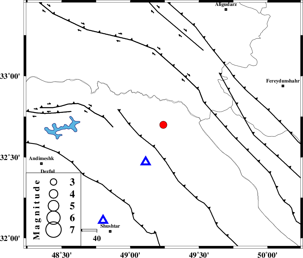
| Location | Lat:32.7 Lon: 49.24 |
| Region | Khoozestan Province, 36 km North-East of Lali |
Nearest Cities |
|
| 32 km South West of Parchal, Lorestan Province | |
| 37 km North East of Lali, Khoozestan Province | |
| 42 km East of Shuy, Khoozestan Province | |
| 44 km North East of Sardasht, Khoozestan Province | |
| 48 km South East of Bargsar, Lorestan Province | |
| Depth | 14 km |
| Agency | |
Faults within 150 km: |
|
| MFF2 (Length: 205 km) , Distance to epicenter: 17 km | |
| HZF4 (Length: 492 km) , Distance to epicenter: 32 km | |
| ZARDKUH_F (Length: 139 km) , Distance to epicenter: 32 km | |
| Number of Phases | 5 |
| RMS | 0.1 |
| Number of Stations | 4 |
| Error in Latitude | >2.5 km |
| Error in Longitude | 6.2 km |
| Error in Depth | 4.4 km |
Download waveform in seisan format
to download seisan software Click here
to access information about IIEES stations Click here
Amplitude | ||||||||
| UID | Agency | Station | Component | Amplitude | Period | Arrival Time | Proccessing Time | Signal Clip |
| 85733 | IIEES | SHGR | N | 1284.3 | 0.56 | 2012-08-24 03:32:39 | 2012-08-24 04:06:00 | n |
| 85734 | IIEES | SHGR | E | 1876.9 | 0.56 | 2012-08-24 03:32:41 | 2012-08-24 04:06:00 | n |
Phase | ||||||||||||
| Agency | Station | Component | Phase Type | Phase Quality | First Motion | Observed Arrival Time | Time Residual | Loc. Flag | Input Weight | Distance | Azimuth | |
| IIEES | SHGR | Z | Pg | E | 2012-08-24 03:32:19 | 0 | y | 77.2 | 212 | |||
| IIEES | ASAO | Z | Pn | E | 2012-08-24 03:32:41 | -0.06 | y | 218 | 19 | |||
| IIEES | ASAO | E | Sg | E | 2012-08-24 03:33:08 | -0.01 | y | 218 | 19 | |||
| IIEES | DAMV | Z | Pn | E | 2012-08-24 03:33:05 | 0.12 | y | 411 | 37 | |||
| IIEES | TABS | Z | Pn | E | 2012-08-24 03:33:46 | -0.08 | y | 743 | 80 | |||