
Magnitude |
:2.4 |
| Date & Time (UTC) | 2012-08-20 16:30:39.7 |
| Date & Time (Local) | 1391/5/30 21:00:39.7 |
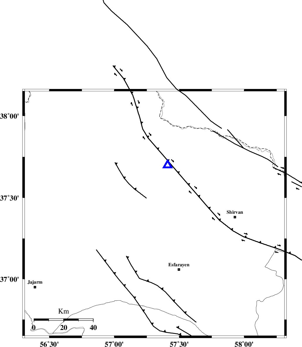
| Location | Lat:37.4 Lon: 57.31 |
| Region | Khorasan(north) Province, 9 km Bojnurd |
Nearest Cities |
|
| 8 km of Bojnurd, Khorasan(north) Province | |
| 8 km of Void, Khorasan(north) Province | |
| 20 km South West of Hesar-egarmkhanh, Khorasan(north) Province | |
| 33 km North West of Eraj, Khorasan(north) Province | |
| 33 km North East of Cheharborj, Khorasan(north) Province | |
| Depth | 15 km |
| Agency | |
Faults within 150 km: |
|
| ESFARAYEN_F (Length: 111 km) , Distance to epicenter: 27 km | |
| ROBATE_QARABIL_F (Length: 168 km) , Distance to epicenter: 27 km | |
| JAJARAM_F (Length: 77 km) , Distance to epicenter: 60 km | |
| Number of Phases | 3 |
| RMS | 0 |
| Number of Stations | 3 |
| Error in Latitude | >2 km |
| Error in Longitude | 3.2 km |
| Error in Depth | 0 km |
Download waveform in seisan format
to download seisan software Click here
to access information about IIEES stations Click here
Amplitude | ||||||||
| UID | Agency | Station | Component | Amplitude | Period | Arrival Time | Proccessing Time | Signal Clip |
| 85641 | IIEES | BJRD | E | 494.6 | 0.32 | 2012-08-20 16:30:54 | 2012-08-21 01:49:00 | n |
| 85642 | IIEES | MRVT | E | 118.5 | 0.28 | 2012-08-20 16:31:18 | 2012-08-21 01:49:00 | n |
| 85643 | IIEES | MRVT | N | 50.3 | 5.79 | 2012-08-20 16:31:20 | 2012-08-21 01:49:00 | n |
Phase | ||||||||||||
| Agency | Station | Component | Phase Type | Phase Quality | First Motion | Observed Arrival Time | Time Residual | Loc. Flag | Input Weight | Distance | Azimuth | |
| IIEES | BJRD | N | Pg | E | 2012-08-20 16:30:46 | 0 | y | 34.7 | 15 | |||
| IIEES | MRVT | Z | Pg | E | 2012-08-20 16:30:58 | -0.01 | y | 111 | 285 | |||
| IIEES | SHRO | Z | Pn | E | 2012-08-20 16:31:11 | 0.01 | y | 193 | 217 | |||