
Magnitude |
:1.8 |
| Date & Time (UTC) | 2012-08-12 12:16:10.3 |
| Date & Time (Local) | 1391/5/22 16:46:10.3 |
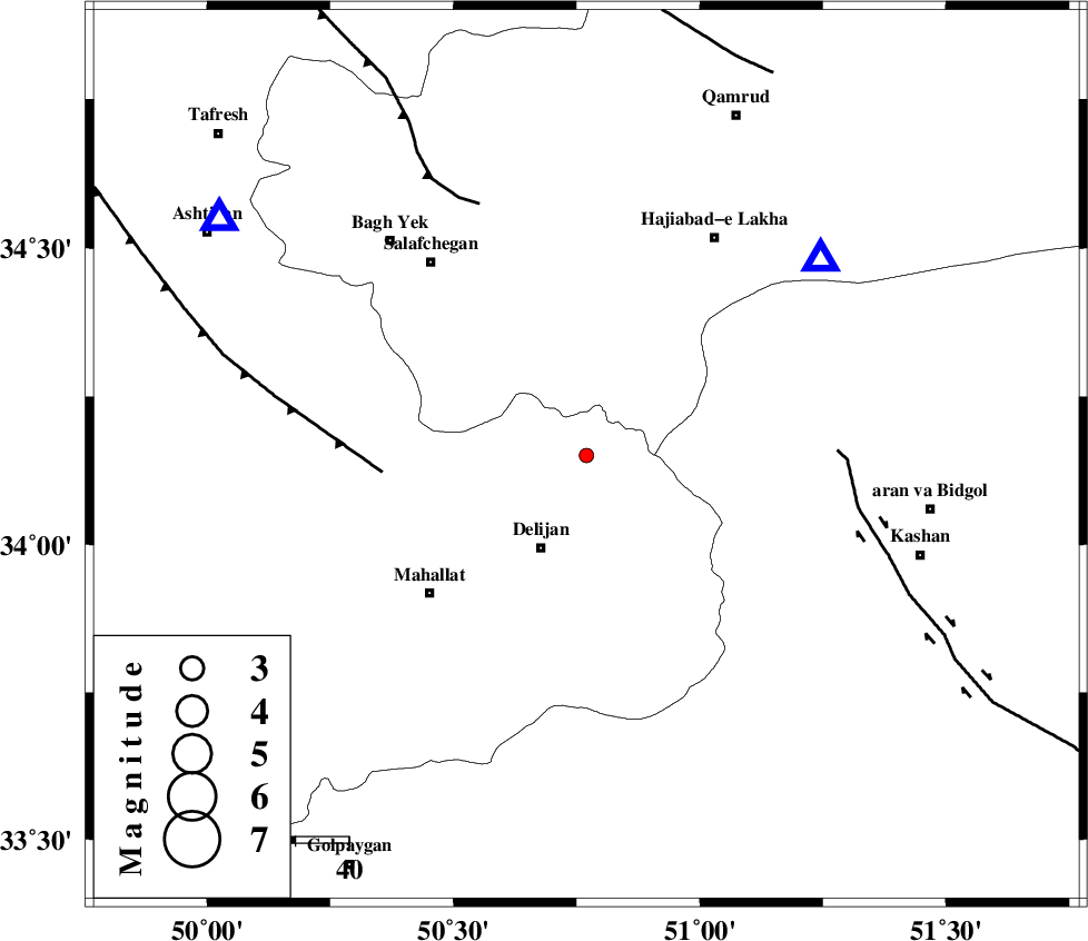
| Location | Lat:34.15 Lon: 50.77 |
| Region | Markazi Province, 19 km North of Delijan |
Nearest Cities |
|
| 5 km North of Vasqonqan, Markazi Province | |
| 17 km North of Naraq, Markazi Province | |
| 18 km North East of Dudhak, Markazi Province | |
| 19 km North West of Joshaq, Markazi Province | |
| 19 km North of Delijan, Markazi Province | |
| Depth | 23 km |
| Agency | |
Faults within 150 km: |
|
| TAFRESH_F (Length: 117 km) , Distance to epicenter: 38 km | |
| KASHAN_F (Length: 44 km) , Distance to epicenter: 47 km | |
| INDES_F (Length: 98 km) , Distance to epicenter: 51 km | |
| Number of Phases | 5 |
| RMS | 0 |
| Number of Stations | 4 |
| Error in Latitude | >2.4 km |
| Error in Longitude | 2.3 km |
| Error in Depth | 3.4 km |
Download waveform in seisan format
to download seisan software Click here
to access information about IIEES stations Click here
Amplitude | ||||||||
| UID | Agency | Station | Component | Amplitude | Period | Arrival Time | Proccessing Time | Signal Clip |
| 85132 | IIEES | GHVR | E | 66.8 | 0.32 | 2012-08-12 12:16:30 | 2012-08-12 12:59:00 | n |
| 85133 | IIEES | GHVR | N | 80.3 | 0.68 | 2012-08-12 12:16:32 | 2012-08-12 12:59:00 | n |
| 85134 | IIEES | KHMZ | N | 32.3 | 0.44 | 2012-08-12 12:16:37 | 2012-08-12 12:59:00 | n |
Phase | ||||||||||||
| Agency | Station | Component | Phase Type | Phase Quality | First Motion | Observed Arrival Time | Time Residual | Loc. Flag | Input Weight | Distance | Azimuth | |
| IIEES | GHVR | Z | Pg | E | 2012-08-12 12:16:20 | 0 | y | 57.2 | 49 | |||
| IIEES | ASAO | Z | Pg | E | 2012-08-12 12:16:24 | 0 | y | 82 | 303 | |||
| IIEES | KHMZ | Z | Pg | E | 2012-08-12 12:16:25 | 0.01 | y | 87.2 | 239 | |||
| IIEES | KHMZ | E | Sg | E | 2012-08-12 12:16:36 | 0 | y | 87.2 | 239 | |||
| IIEES | CHTH | Z | Pn | E | 2012-08-12 12:16:42 | 0 | y | 198 | 9 | |||