
Magnitude |
:3.8 |
| Date & Time (UTC) | 2012-08-11 11:14:21.7 |
| Date & Time (Local) | 1391/5/21 15:44:21.7 |
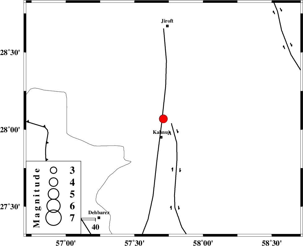
| Location | Lat:28.07 Lon: 57.71 |
| Region | Kerman Province, 14 km North of Kahnuj |
Nearest Cities |
|
| 13 km North of Kahnuj, Kerman Province | |
| 23 km South East of Bolock, Kerman Province | |
| 30 km East of Mehrueye-e paeen, Kerman Province | |
| 41 km South East of Hurpasefid, Kerman Province | |
| 43 km North East of Faryab, Kerman Province | |
| Depth | 30 km |
| Agency | |
Faults within 150 km: |
|
| SABZEVARAN_F (Length: 190 km) , Distance to epicenter: 3 km | |
| JIROFT_F (Length: 144 km) , Distance to epicenter: 7 km | |
| MAIN_ZAGROS_R_F (Length: 1106 km) , Distance to epicenter: 83 km | |
| Number of Phases | 4 |
| RMS | 0 |
| Number of Stations | 3 |
| Error in Latitude | >4.3 km |
| Error in Longitude | 7.4 km |
| Error in Depth | 4.3 km |
Download waveform in seisan format
to download seisan software Click here
to access information about IIEES stations Click here
Amplitude | ||||||||
| UID | Agency | Station | Component | Amplitude | Period | Arrival Time | Proccessing Time | Signal Clip |
| 84917 | IIEES | BNDS | E | 1487.5 | 0.44 | 2012-08-11 11:15:12 | 2012-08-11 11:31:00 | n |
| 84918 | IIEES | KRBR | N | 710.2 | 0.52 | 2012-08-11 11:15:33 | 2012-08-11 11:31:00 | n |
| 84919 | IIEES | KRBR | E | 613.9 | 0.36 | 2012-08-11 11:15:36 | 2012-08-11 11:31:00 | n |
Phase | ||||||||||||
| Agency | Station | Component | Phase Type | Phase Quality | First Motion | Observed Arrival Time | Time Residual | Loc. Flag | Input Weight | Distance | Azimuth | |
| IIEES | BNDS | Z | Pg | E | 2012-08-11 11:14:49 | 0 | y | 169 | 244 | |||
| IIEES | BNDS | E | Sg | E | 2012-08-11 11:15:09 | 0 | y | 169 | 244 | |||
| IIEES | KRBR | Z | Pg | E | 2012-08-11 11:14:58 | 0 | y | 231 | 337 | |||
| IIEES | GHIR | Z | Pn | E | 2012-08-11 11:15:25 | 0 | y | 465 | 274 | |||