
Magnitude |
:2.9 |
| Date & Time (UTC) | 2012-08-10 06:14:27.8 |
| Date & Time (Local) | 1391/5/20 10:44:27.8 |
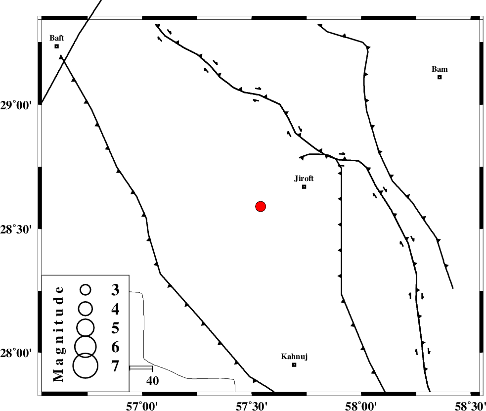
| Location | Lat:28.59 Lon: 57.54 |
| Region | Kerman Province, 21 km West of Jiroft |
Nearest Cities |
|
| 16 km North West of Khatunabad-e zangian, Kerman Province | |
| 21 km West of Jiroft, Kerman Province | |
| 27 km West of Dolatabad, Kerman Province | |
| 31 km North West of Khesrabad, Kerman Province | |
| 36 km North West of Aliabad-e qadiri, Kerman Province | |
| Depth | 14 km |
| Agency | |
Faults within 150 km: |
|
| SABZEVARAN_F (Length: 190 km) , Distance to epicenter: 18 km | |
| GOWK_F (Length: 152 km) , Distance to epicenter: 60 km | |
| JIROFT_F (Length: 144 km) , Distance to epicenter: 65 km | |
| Number of Phases | 4 |
| RMS | 0 |
| Number of Stations | 3 |
| Error in Latitude | >3.2 km |
| Error in Longitude | 9.7 km |
| Error in Depth | 4.8 km |
Download waveform in seisan format
to download seisan software Click here
to access information about IIEES stations Click here
Amplitude | ||||||||
| UID | Agency | Station | Component | Amplitude | Period | Arrival Time | Proccessing Time | Signal Clip |
| 84882 | IIEES | BNDS | E | 113.7 | 0.32 | 2012-08-10 06:15:28 | 2012-08-10 07:52:00 | n |
| 84883 | IIEES | GHIR | E | 21.4 | 0.4 | 2012-08-10 06:16:23 | 2012-08-10 07:52:00 | n |
| 84884 | IIEES | GHIR | N | 18 | 0.32 | 2012-08-10 06:16:24 | 2012-08-10 07:52:00 | n |
Phase | ||||||||||||
| Agency | Station | Component | Phase Type | Phase Quality | First Motion | Observed Arrival Time | Time Residual | Loc. Flag | Input Weight | Distance | Azimuth | |
| IIEES | KRBR | Z | Pg | E | 2012-08-10 06:14:56 | -0.03 | y | 172 | 334 | |||
| IIEES | BNDS | Z | Pg | E | 2012-08-10 06:14:58 | 0 | y | 189 | 226 | |||
| IIEES | BNDS | E | Sg | E | 2012-08-10 06:15:21 | -0.02 | y | 189 | 226 | |||
| IIEES | GHIR | Z | Pn | E | 2012-08-10 06:15:31 | 0.08 | y | 447 | 267 | |||