
Magnitude |
:2.5 |
| Date & Time (UTC) | 2012-08-09 16:43:18.6 |
| Date & Time (Local) | 1391/5/19 21:13:18.6 |
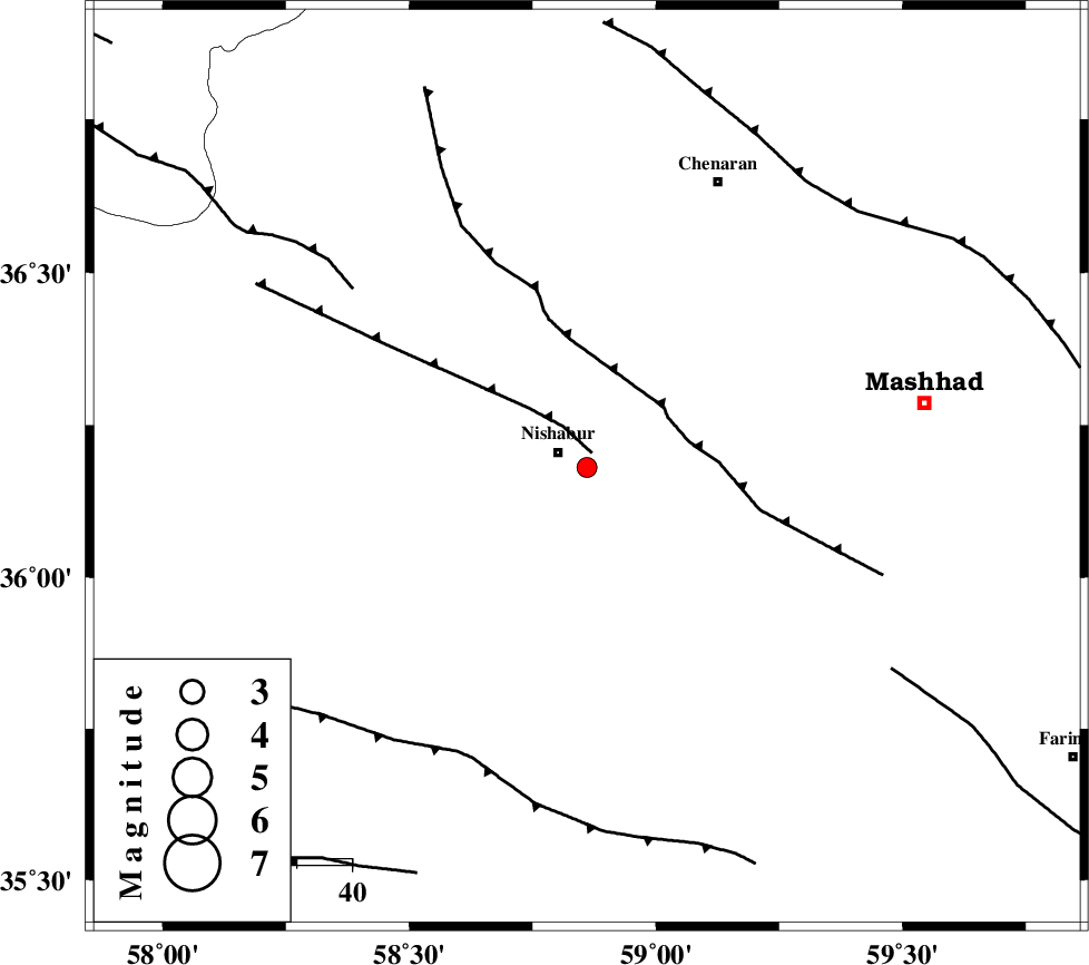
| Location | Lat:36.18 Lon: 58.86 |
| Region | Khorasan(center) Province, 6 km Neyshabur |
Nearest Cities |
|
| 4 km North of Abusaeedi, Khorasan(center) Province | |
| 6 km of Neyshabur, Khorasan(center) Province | |
| 16 km East of Fatanabad, Khorasan(center) Province | |
| 21 km North West of Eshaqabad, Khorasan(center) Province | |
| 23 km North West of Darrud, Khorasan(center) Province | |
| Depth | 15 km |
| Agency | |
Faults within 150 km: |
|
| NAYSHABUR_F (Length: 74 km) , Distance to epicenter: 3 km | |
| BINALUD_F1 (Length: 129 km) , Distance to epicenter: 17 km | |
| RIVAND_F (Length: 70 km) , Distance to epicenter: 54 km | |
| Number of Phases | 4 |
| RMS | 0.1 |
| Number of Stations | 4 |
| Error in Latitude | >2.1 km |
| Error in Longitude | 5.3 km |
| Error in Depth | 0 km |
Download waveform in seisan format
to download seisan software Click here
to access information about IIEES stations Click here
Amplitude | ||||||||
| UID | Agency | Station | Component | Amplitude | Period | Arrival Time | Proccessing Time | Signal Clip |
| 84855 | IIEES | SHRO | N | 28 | 0.28 | 2012-08-09 16:44:32 | 2012-08-09 05:15:00 | n |
| 84856 | IIEES | SHRO | E | 27 | 0.3 | 2012-08-09 16:44:32 | 2012-08-09 05:15:00 | n |
Phase | ||||||||||||
| Agency | Station | Component | Phase Type | Phase Quality | First Motion | Observed Arrival Time | Time Residual | Loc. Flag | Input Weight | Distance | Azimuth | |
| IIEES | BJRD | N | Pn | E | 2012-08-09 16:43:52 | 0.07 | y | 213 | 323 | |||
| IIEES | SHRO | Z | Pn | E | 2012-08-09 16:43:58 | 0.06 | y | 257 | 267 | |||
| IIEES | MRVT | Z | Pn | E | 2012-08-09 16:44:03 | -0.13 | y | 297 | 305 | |||
| IIEES | TABS | Z | Pn | E | 2012-08-09 16:44:06 | -0.02 | y | 322 | 210 | |||