
Magnitude |
:3.6 |
| Date & Time (UTC) | 2012-08-05 19:54:44.5 |
| Date & Time (Local) | 1391/5/16 00:24:44.5 |
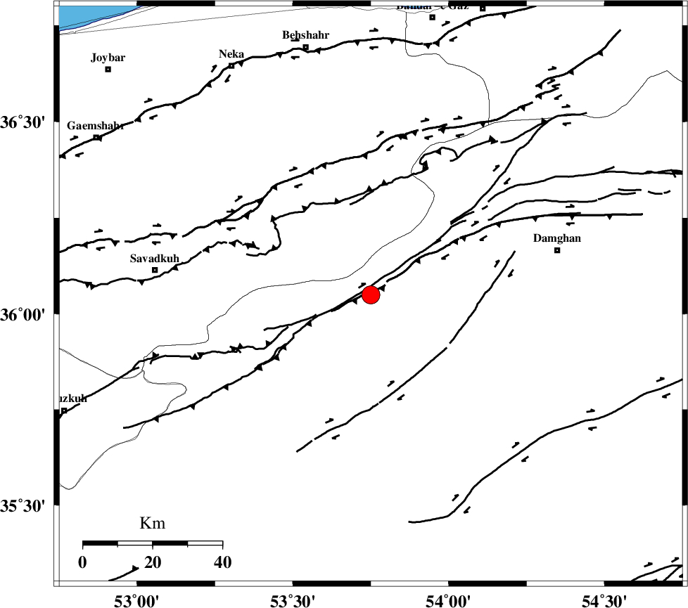
| Location | Lat:36.05 Lon: 53.75 |
| Region | Semnan Province, 55 km South-West of Damghan |
Nearest Cities |
|
| 16 km North West of Darvar, Semnan Province | |
| 19 km South of Talma darreh, Mazandaran Province | |
| 28 km South East of Kiasar, Mazandaran Province | |
| 36 km North West of Amirabad, Semnan Province | |
| 36 km West of Seydabad, Semnan Province | |
| Depth | 14 km |
| Agency | |
Faults within 150 km: |
|
| DAMGHAN_F (Length: 95 km) , Distance to epicenter: 13 km | |
| ATARI_F (Length: 185 km) , Distance to epicenter: 20 km | |
| ASTANEH_F (Length: 72 km) , Distance to epicenter: 30 km | |
| Number of Phases | 6 |
| RMS | 0.1 |
| Number of Stations | 5 |
| Error in Latitude | >3.9 km |
| Error in Longitude | 4.2 km |
| Error in Depth | 8.4 km |
Download waveform in seisan format
to download seisan software Click here
to access information about IIEES stations Click here
Amplitude | ||||||||
| UID | Agency | Station | Component | Amplitude | Period | Arrival Time | Proccessing Time | Signal Clip |
| 84795 | IIEES | GHVR | E | 248.1 | 0.4 | 2012-08-05 19:56:14 | 2012-08-05 08:15:00 | n |
| 84796 | IIEES | GHVR | N | 294 | 0.56 | 2012-08-05 19:56:16 | 2012-08-05 08:15:00 | n |
Phase | ||||||||||||
| Agency | Station | Component | Phase Type | Phase Quality | First Motion | Observed Arrival Time | Time Residual | Loc. Flag | Input Weight | Distance | Azimuth | |
| IIEES | DAMV | Z | P | E | 2012-08-05 19:55:11 | -0.16 | y | 168 | 254 | |||
| IIEES | SHRO | Z | Pn | E | 2012-08-05 19:55:17 | -0.18 | y | 204 | 91 | |||
| IIEES | MRVT | Z | Pn | E | 2012-08-05 19:55:26 | 0.09 | y | 274 | 49 | |||
| IIEES | GHVR | Z | Pn | E | 2012-08-05 19:55:28 | 0.26 | y | 287 | 233 | |||
| IIEES | GHVR | N | Sg | E | 2012-08-05 19:56:05 | -0.01 | y | 287 | 233 | |||
| IIEES | NASN | Z | Pn | E | 2012-08-05 19:55:38 | 0.02 | y | 371 | 194 | |||