
Magnitude |
:3 |
| Date & Time (UTC) | 2012-08-02 19:40:36.5 |
| Date & Time (Local) | 1391/5/13 00:10:36.5 |
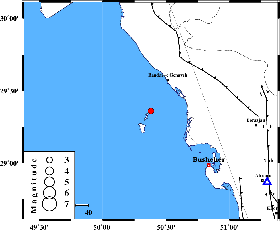
| Location | Lat:29.36 Lon: 50.38 |
| Region | Persian Gulf, 28 km South-West of Bandar-e genaveh |
Nearest Cities |
|
| 27 km South West of Bandar-e genaveh, Bushehr Province | |
| 28 km South West of Bandarehrig, Bushehr Province | |
| 39 km South West of Mohammad salehi, Bushehr Province | |
| 44 km South West of Chehar rustaee, Bushehr Province | |
| 53 km North West of Kareband, Bushehr Province | |
| Depth | 14 km |
| Agency | |
Faults within 150 km: |
|
| ZFF3 (Length: 125 km) , Distance to epicenter: 46 km | |
| ZFF2 (Length: 84 km) , Distance to epicenter: 85 km | |
| BORAZJAN_F (Length: 168 km) , Distance to epicenter: 86 km | |
| Number of Phases | 5 |
| RMS | 0.1 |
| Number of Stations | 4 |
| Error in Latitude | >5 km |
| Error in Longitude | 6.2 km |
| Error in Depth | 5.5 km |
Download waveform in seisan format
to download seisan software Click here
to access information about IIEES stations Click here
Amplitude | ||||||||
| UID | Agency | Station | Component | Amplitude | Period | Arrival Time | Proccessing Time | Signal Clip |
| 84731 | IIEES | AHRM | E | 400.4 | 0.44 | 2012-08-02 19:41:11 | 2012-08-02 09:10:00 | n |
| 84732 | IIEES | GHIR | N | 56 | 0.32 | 2012-08-02 19:42:03 | 2012-08-02 09:10:00 | n |
| 84733 | IIEES | GHIR | E | 68.5 | 0.72 | 2012-08-02 19:42:07 | 2012-08-02 09:10:00 | n |
| 84734 | IIEES | KHMZ | E | 15.5 | 0.76 | 2012-08-02 19:42:41 | 2012-08-02 09:10:00 | n |
Phase | ||||||||||||
| Agency | Station | Component | Phase Type | Phase Quality | First Motion | Observed Arrival Time | Time Residual | Loc. Flag | Input Weight | Distance | Azimuth | |
| IIEES | AHRM | Z | Pg | E | 2012-08-02 19:40:54 | -0.05 | y | 104 | 121 | |||
| IIEES | GHIR | E | Pn | E | 2012-08-02 19:41:19 | 0.06 | y | 281 | 114 | |||
| IIEES | GHIR | E | Sg | E | 2012-08-02 19:41:55 | 0.01 | y | 281 | 114 | |||
| IIEES | KHMZ | Z | Pn | E | 2012-08-02 19:41:44 | -0.11 | y | 488 | 355 | |||
| IIEES | ASAO | Z | Pn | E | 2012-08-02 19:41:56 | 0.1 | y | 577 | 357 | |||