
Magnitude |
:2.9 |
| Date & Time (UTC) | 2012-08-01 07:45:29.6 |
| Date & Time (Local) | 1391/5/11 12:15:29.6 |
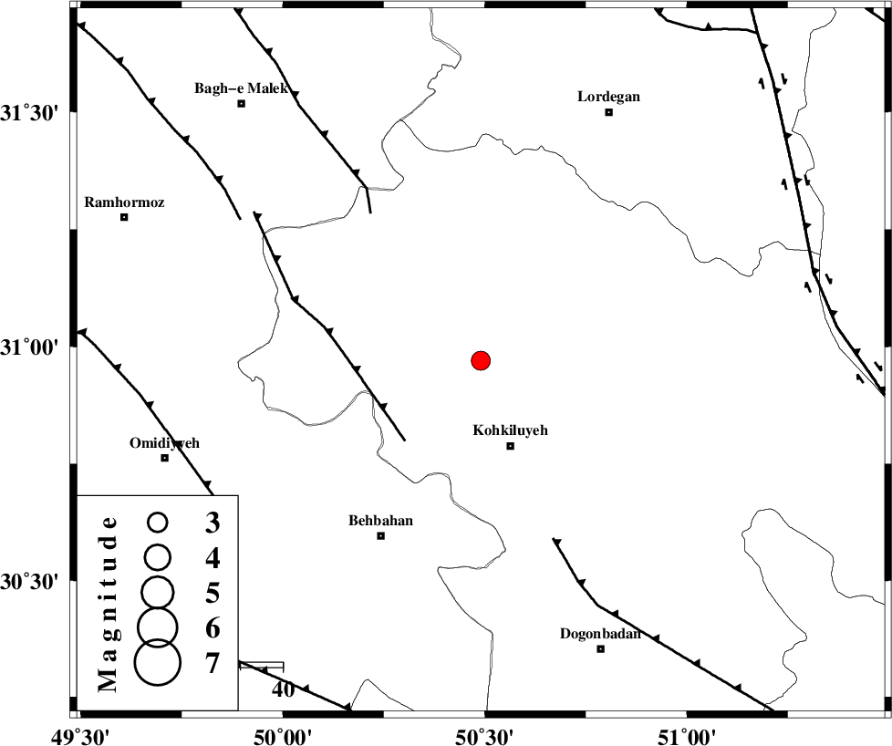
| Location | Lat:30.97 Lon: 50.49 |
| Region | Kohkiluieh va boyerahmad Province, 22 km North of Dehdasht |
Nearest Cities |
|
| 6 km of Lendeh, Kohkiluieh va boyerahmad Province | |
| 21 km North of Dehdasht, Kohkiluieh va boyerahmad Province | |
| 25 km South of Qale-ye raiesi, Kohkiluieh va boyerahmad Province | |
| 27 km North West of Savari, Kohkiluieh va boyerahmad Province | |
| 37 km South of Dishmuk, Kohkiluieh va boyerahmad Province | |
| Depth | 46 km |
| Agency | |
Faults within 150 km: |
|
| MFF4 (Length: 62 km) , Distance to epicenter: 26 km | |
| MFF2 (Length: 205 km) , Distance to epicenter: 43 km | |
| MISHAN_F (Length: 76 km) , Distance to epicenter: 45 km | |
| Number of Phases | 7 |
| RMS | 0.2 |
| Number of Stations | 6 |
| Error in Latitude | >2.8 km |
| Error in Longitude | 7.3 km |
| Error in Depth | 9.2 km |
Download waveform in seisan format
to download seisan software Click here
to access information about IIEES stations Click here
Amplitude | ||||||||
| UID | Agency | Station | Component | Amplitude | Period | Arrival Time | Proccessing Time | Signal Clip |
| 84697 | IIEES | SHGR | E | 145.7 | 0.36 | 2012-08-01 07:46:34 | 2012-08-01 08:25:00 | n |
| 84698 | IIEES | AHRM | N | 62.4 | 0.53 | 2012-08-01 07:46:51 | 2012-08-01 08:25:00 | n |
| 84699 | IIEES | AHRM | E | 73.1 | 0.42 | 2012-08-01 07:46:51 | 2012-08-01 08:25:00 | n |
Phase | ||||||||||||
| Agency | Station | Component | Phase Type | Phase Quality | First Motion | Observed Arrival Time | Time Residual | Loc. Flag | Input Weight | Distance | Azimuth | |
| IIEES | SHGR | Z | Pg | E | 2012-08-01 07:46:03 | 0.13 | y | 204 | 309 | |||
| IIEES | SHGR | E | Sg | E | 2012-08-01 07:46:27 | -0.01 | y | 204 | 309 | |||
| IIEES | AHRM | Z | Pn | E | 2012-08-01 07:46:04 | -0.02 | y | 246 | 161 | |||
| IIEES | NASN | Z | Pn | E | 2012-08-01 07:46:11 | 0.01 | y | 299 | 47 | |||
| IIEES | KHMZ | Z | Pn | E | 2012-08-01 07:46:12 | -0.25 | y | 311 | 351 | |||
| IIEES | GHVR | Z | P | E | 2012-08-01 07:46:23 | 0.38 | y | 396 | 10 | |||
| IIEES | ASAO | Z | Pn | E | 2012-08-01 07:46:23 | -0.24 | y | 399 | 354 | |||