
Magnitude |
:2.8 |
| Date & Time (UTC) | 2012-07-15 22:26:25.0 |
| Date & Time (Local) | 1391/4/26 02:56:25.0 |
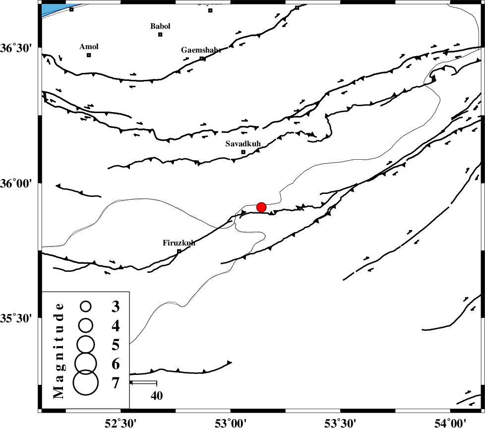
| Location | Lat:35.91 Lon: 53.14 |
| Region | Semnan Province, 24 km South of Pol-E-Sefid |
Nearest Cities |
|
| 11 km North West of Chashem, Semnan Province | |
| 19 km South of Sangdeh, Mazandaran Province | |
| 22 km South of Shurmast-e peyrudbar, Mazandaran Province | |
| 23 km North West of Shahmirzad, Semnan Province | |
| 24 km South of Pol-E-Sefid, Mazandaran Province | |
| Depth | 14 km |
| Agency | |
Faults within 150 km: |
|
| ATARI_F (Length: 185 km) , Distance to epicenter: 25 km | |
| N_ALBORZ_F (Length: 360 km) , Distance to epicenter: 33 km | |
| MOSHA_F (Length: 234 km) , Distance to epicenter: 51 km | |
| Number of Phases | 5 |
| RMS | 0.1 |
| Number of Stations | 4 |
| Error in Latitude | >4.8 km |
| Error in Longitude | 2.9 km |
| Error in Depth | 8.3 km |
Download waveform in seisan format
to download seisan software Click here
to access information about IIEES stations Click here
Amplitude | ||||||||
| UID | Agency | Station | Component | Amplitude | Period | Arrival Time | Proccessing Time | Signal Clip |
| 84479 | IIEES | GHVR | E | 62.7 | 0.4 | 2012-07-15 22:27:37 | 2012-07-16 02:23:00 | n |
| 84480 | IIEES | GHVR | N | 66.4 | 0.48 | 2012-07-15 22:27:37 | 2012-07-16 02:23:00 | n |
Phase | ||||||||||||
| Agency | Station | Component | Phase Type | Phase Quality | First Motion | Observed Arrival Time | Time Residual | Loc. Flag | Input Weight | Distance | Azimuth | |
| IIEES | THKV | Z | Pn | E | 2012-07-15 22:26:58 | 0.08 | y | 204 | 271 | |||
| IIEES | GHVR | Z | Pn | E | 2012-07-15 22:27:01 | 0.06 | y | 234 | 228 | |||
| IIEES | GHVR | E | Sg | E | 2012-07-15 22:27:31 | -0.09 | y | 234 | 228 | |||
| IIEES | SHRO | Z | Pn | E | 2012-07-15 22:27:05 | 0.11 | y | 260 | 87 | |||
| IIEES | MRVT | Z | Pn | E | 2012-07-15 22:27:13 | -0.18 | y | 327 | 53 | |||