
Magnitude |
:3.2 |
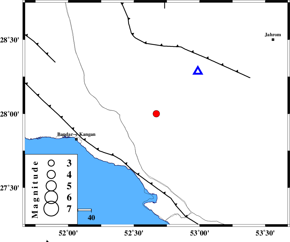
| Date & Time (UTC) | 2012-07-08 15:03:23.8 |
| Date & Time (Local) | 1391/4/18 19:33:23.8 |
| Location | Lat:28 Lon: 52.67 |
| Region | Fars Province, 39 km North-East of Jam |
Nearest Cities |
|
| 6 km of Garmesht, Fars Province | |
| 30 km North of Asir, Fars Province | |
| 38 km North of Gallehdar, Fars Province | |
| 39 km North East of Jam, Bushehr Province | |
| 41 km South East of Dolatabad, Fars Province | |
| Depth | 16 km |
| Agency | |
Faults within 150 km: |
|
| MFF3 (Length: 292 km) , Distance to epicenter: 44 km | |
| QIR_F (Length: 130 km) , Distance to epicenter: 51 km | |
| SABZ_PUSHAN_F_Z1 (Length: 69 km) , Distance to epicenter: 79 km | |
| Number of Phases | 5 |
| RMS | 0.1 |
| Number of Stations | 4 |
| Error in Latitude | >3.3 km |
| Error in Longitude | 1.6 km |
| Error in Depth | 3.8 km |
Download waveform in seisan format
to download seisan software Click here
to access information about IIEES stations Click here
Amplitude | ||||||||
| UID | Agency | Station | Component | Amplitude | Period | Arrival Time | Proccessing Time | Signal Clip |
| 84417 | IIEES | GHIR | N | 4540.7 | 0.64 | 2012-07-08 15:03:40 | 2012-07-08 04:00:00 | n |
| 84418 | IIEES | GHIR | E | 4161 | 0.44 | 2012-07-08 15:03:41 | 2012-07-08 04:00:00 | n |
| 84419 | IIEES | AHRM | E | 292.6 | 0.44 | 2012-07-08 15:04:17 | 2012-07-08 04:00:00 | n |
| 84420 | IIEES | AHRM | N | 208.4 | 0.48 | 2012-07-08 15:04:19 | 2012-07-08 04:00:00 | n |
| 84421 | IIEES | BNDS | E | 32.9 | 0.52 | 2012-07-08 15:05:19 | 2012-07-08 04:00:00 | n |
| 84422 | IIEES | BNDS | N | 35.8 | 0.52 | 2012-07-08 15:05:33 | 2012-07-08 04:00:00 | n |
Phase | ||||||||||||
| Agency | Station | Component | Phase Type | Phase Quality | First Motion | Observed Arrival Time | Time Residual | Loc. Flag | Input Weight | Distance | Azimuth | |
| IIEES | GHIR | Z | Pg | E | 2012-07-08 15:03:32 | 0.09 | y | 44.6 | 45 | |||
| IIEES | GHIR | N | Sg | E | 2012-07-08 15:03:38 | -0.06 | y | 44.6 | 45 | |||
| IIEES | AHRM | Z | Pg | E | 2012-07-08 15:03:51 | -0.03 | y | 165 | 306 | |||
| IIEES | BNDS | Z | Pn | E | 2012-07-08 15:04:15 | -0.03 | y | 352 | 100 | |||
| IIEES | NASN | Z | Pn | E | 2012-07-08 15:04:37 | 0.04 | y | 532 | 1 | |||