
Magnitude |
:2.7 |
| Date & Time (UTC) | 2012-07-06 00:20:35.4 |
| Date & Time (Local) | 1391/4/16 04:50:35.4 |
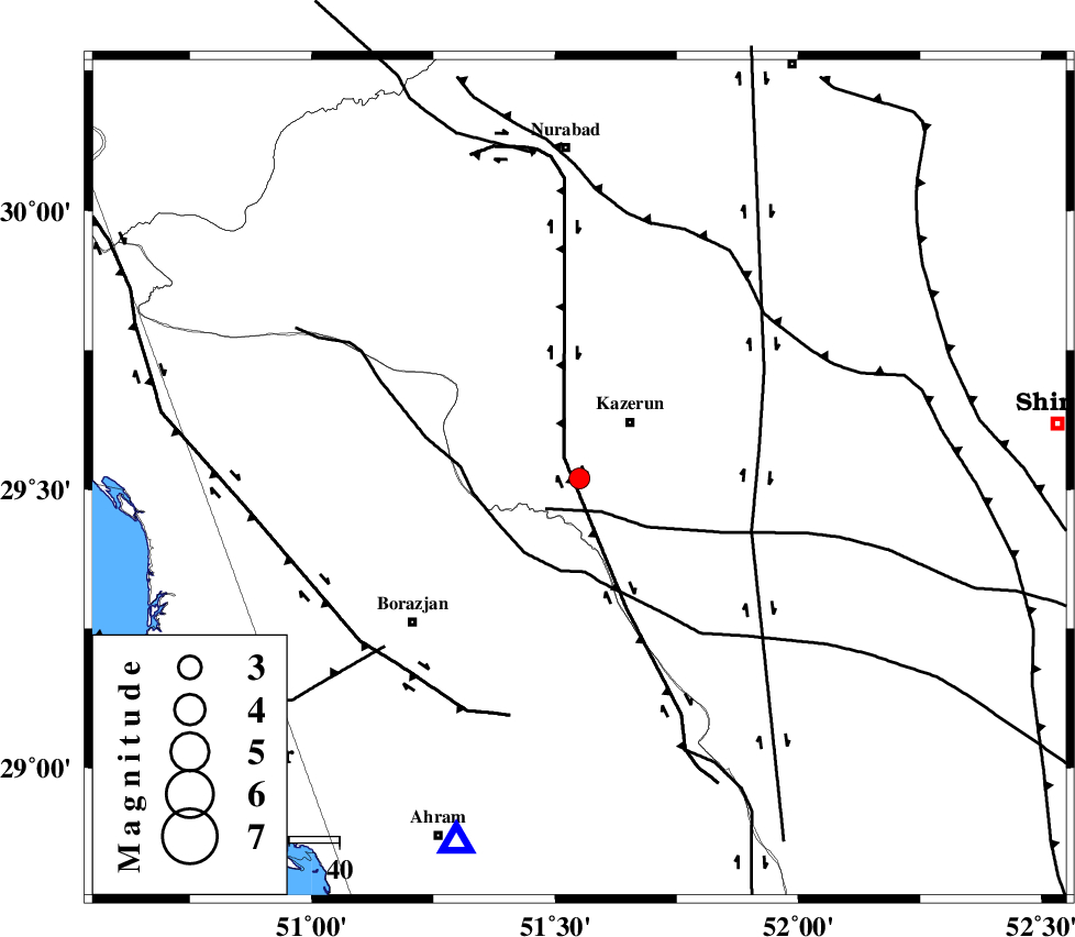
| Location | Lat:29.52 Lon: 51.55 |
| Region | Fars Province, 15 km West of Kazerun |
Nearest Cities |
|
| 11 km West of Mehranjan, Fars Province | |
| 14 km South of Kamaraj, Fars Province | |
| 15 km South West of Kazerun, Fars Province | |
| 18 km South of Deris, Fars Province | |
| 21 km East of Khesht, Fars Province | |
| Depth | 6 km |
| Agency | |
Faults within 150 km: |
|
| KAZERUN_F (Length: 96 km) , Distance to epicenter: 8 km | |
| BORAZJAN_F (Length: 168 km) , Distance to epicenter: 26 km | |
| ZFF3 (Length: 125 km) , Distance to epicenter: 38 km | |
| Number of Phases | 5 |
| RMS | 0.1 |
| Number of Stations | 4 |
| Error in Latitude | >2.8 km |
| Error in Longitude | 5.2 km |
| Error in Depth | 9.1 km |
Download waveform in seisan format
to download seisan software Click here
to access information about IIEES stations Click here
Amplitude | ||||||||
| UID | Agency | Station | Component | Amplitude | Period | Arrival Time | Proccessing Time | Signal Clip |
| 84390 | IIEES | AHRM | E | 201.8 | 0.44 | 2012-07-06 00:21:10 | 2012-07-06 01:14:00 | n |
| 84391 | IIEES | AHRM | N | 238.4 | 0.56 | 2012-07-06 00:21:12 | 2012-07-06 01:14:00 | n |
| 84392 | IIEES | GHIR | N | 146.5 | 0.48 | 2012-07-06 00:21:48 | 2012-07-06 01:14:00 | n |
| 84393 | IIEES | GHIR | E | 135.5 | 0.52 | 2012-07-06 00:21:53 | 2012-07-06 01:14:00 | n |
Phase | ||||||||||||
| Agency | Station | Component | Phase Type | Phase Quality | First Motion | Observed Arrival Time | Time Residual | Loc. Flag | Input Weight | Distance | Azimuth | |
| IIEES | AHRM | Z | Pg | E | 2012-07-06 00:20:48 | -0.1 | y | 77 | 199 | |||
| IIEES | AHRM | N | Sg | E | 2012-07-06 00:20:58 | 0.07 | y | 77 | 199 | |||
| IIEES | GHIR | Z | Pn | E | 2012-07-06 00:21:08 | 0.01 | y | 196 | 134 | |||
| IIEES | ASAO | Z | Pn | E | 2012-07-06 00:21:55 | 0.05 | y | 575 | 346 | |||
| IIEES | SNGE | Z | Pn | E | 2012-07-06 00:22:15 | -0.03 | y | 733 | 328 | |||