
Magnitude |
:2.2 |
| Date & Time (UTC) | 2012-07-03 21:42:40.7 |
| Date & Time (Local) | 1391/4/14 02:12:40.7 |
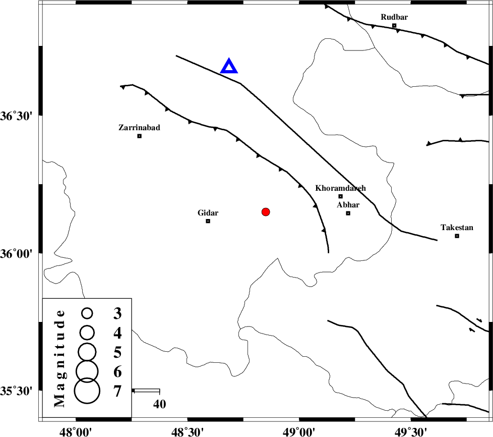
| Location | Lat:36.15 Lon: 48.85 |
| Region | Zanjan Province, 23 km East of Qeydar |
Nearest Cities |
|
| 3 km North of Kineh vars, Zanjan Province | |
| 16 km South of Saeen qaleh, Zanjan Province | |
| 19 km West of Kinehvars, Zanjan Province | |
| 23 km North East of Qeydar, Zanjan Province | |
| 26 km South West of Void, Zanjan Province | |
| Depth | 14 km |
| Agency | |
Faults within 150 km: |
|
| SOLTANIYEH_F (Length: 119 km) , Distance to epicenter: 18 km | |
| ZANJAN_F (Length: 137 km) , Distance to epicenter: 32 km | |
| KUSHK_E_NOSRAT_F (Length: 230 km) , Distance to epicenter: 51 km | |
| Number of Phases | 4 |
| RMS | 0 |
| Number of Stations | 4 |
| Error in Latitude | >3.2 km |
| Error in Longitude | 5.3 km |
| Error in Depth | 5.4 km |
Download waveform in seisan format
to download seisan software Click here
to access information about IIEES stations Click here
Amplitude | ||||||||
| UID | Agency | Station | Component | Amplitude | Period | Arrival Time | Proccessing Time | Signal Clip |
| 84375 | IIEES | ZNJK | N | 67.1 | 0.44 | 2012-07-03 21:43:04 | 2012-07-04 02:49:00 | n |
| 84376 | IIEES | THKV | E | 49.3 | 0.56 | 2012-07-03 21:43:42 | 2012-07-04 02:49:00 | n |
| 84377 | IIEES | THKV | N | 50.8 | 0.52 | 2012-07-03 21:43:54 | 2012-07-04 02:49:00 | n |
| 84378 | IIEES | GRMI | N | 8.5 | 0.48 | 2012-07-03 21:44:13 | 2012-07-04 02:49:00 | n |
Phase | ||||||||||||
| Agency | Station | Component | Phase Type | Phase Quality | First Motion | Observed Arrival Time | Time Residual | Loc. Flag | Input Weight | Distance | Azimuth | |
| IIEES | ZNJK | Z | Pg | E | 2012-07-03 21:42:51 | 0 | y | 60 | 346 | |||
| IIEES | THKV | Z | Pg | E | 2012-07-03 21:43:11 | 0 | y | 185 | 97 | |||
| IIEES | KHMZ | Z | Pn | E | 2012-07-03 21:43:24 | 0 | y | 286 | 159 | |||
| IIEES | GRMI | Z | Pn | E | 2012-07-03 21:43:26 | 0 | y | 307 | 344 | |||