
Magnitude |
:3.4 |
| Date & Time (UTC) | 2012-07-04 00:06:05.4 |
| Date & Time (Local) | 1391/4/14 04:36:05.4 |
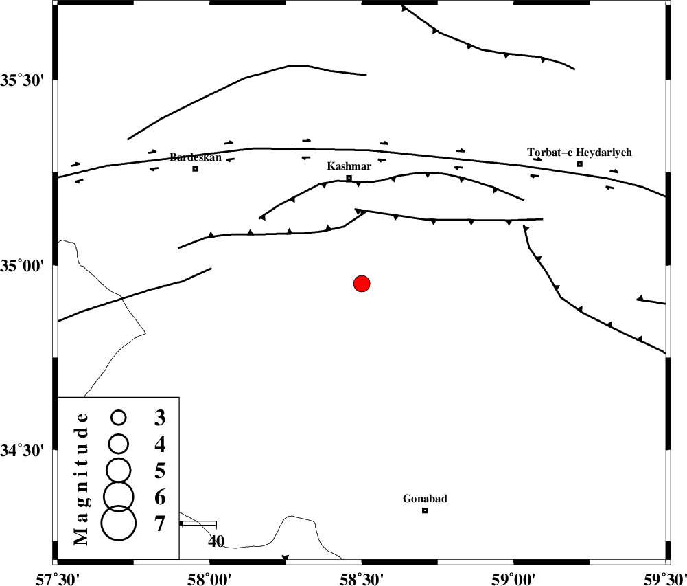
| Location | Lat:34.95 Lon: 58.5 |
| Region | Khorasan(center) Province, 32 km South of Kashmar |
Nearest Cities |
|
| 17 km North of Yoonesi, Khorasan(center) Province | |
| 27 km West of Feizabad, Khorasan(center) Province | |
| 32 km South of Kashmar, Khorasan(center) Province | |
| 32 km West of Mahneh, Khorasan(center) Province | |
| 35 km South of Kasrineh, Khorasan(center) Province | |
| Depth | 17 km |
| Agency | |
Faults within 150 km: |
|
| MEHDIABAD_F (Length: 64 km) , Distance to epicenter: 18 km | |
| DUGHABAD_F (Length: 62 km) , Distance to epicenter: 22 km | |
| KASHMAR_F (Length: 91 km) , Distance to epicenter: 30 km | |
| Number of Phases | 5 |
| RMS | 0 |
| Number of Stations | 4 |
| Error in Latitude | >3.3 km |
| Error in Longitude | 2 km |
| Error in Depth | 4.3 km |
Download waveform in seisan format
to download seisan software Click here
to access information about IIEES stations Click here
Amplitude | ||||||||
| UID | Agency | Station | Component | Amplitude | Period | Arrival Time | Proccessing Time | Signal Clip |
| 84372 | IIEES | TABS | E | 239.9 | 0.4 | 2012-07-04 00:07:06 | 2012-07-04 12:58:00 | n |
| 84373 | IIEES | TABS | N | 344.9 | 0.36 | 2012-07-04 00:07:09 | 2012-07-04 12:58:00 | n |
| 84374 | IIEES | SHRT | E | 580.5 | 0.36 | 2012-07-04 00:07:11 | 2012-07-04 12:58:00 | n |
Phase | ||||||||||||
| Agency | Station | Component | Phase Type | Phase Quality | First Motion | Observed Arrival Time | Time Residual | Loc. Flag | Input Weight | Distance | Azimuth | |
| IIEES | TABS | N | Pg | E | 2012-07-04 00:06:37 | 0.03 | y | 192 | 222 | |||
| IIEES | SHRT | Z | Pn | E | 2012-07-04 00:06:40 | 0.06 | y | 219 | 131 | |||
| IIEES | SHRT | E | Sg | E | 2012-07-04 00:07:07 | -0.03 | y | 219 | 131 | |||
| IIEES | SHRO | Z | Pn | E | 2012-07-04 00:06:44 | -0.02 | y | 255 | 298 | |||
| IIEES | KRBR | Z | Pn | E | 2012-07-04 00:07:24 | -0.07 | y | 574 | 197 | |||