
Magnitude |
:3.1 |
| Date & Time (UTC) | 2012-07-01 23:47:16.4 |
| Date & Time (Local) | 1391/4/12 04:17:16.4 |
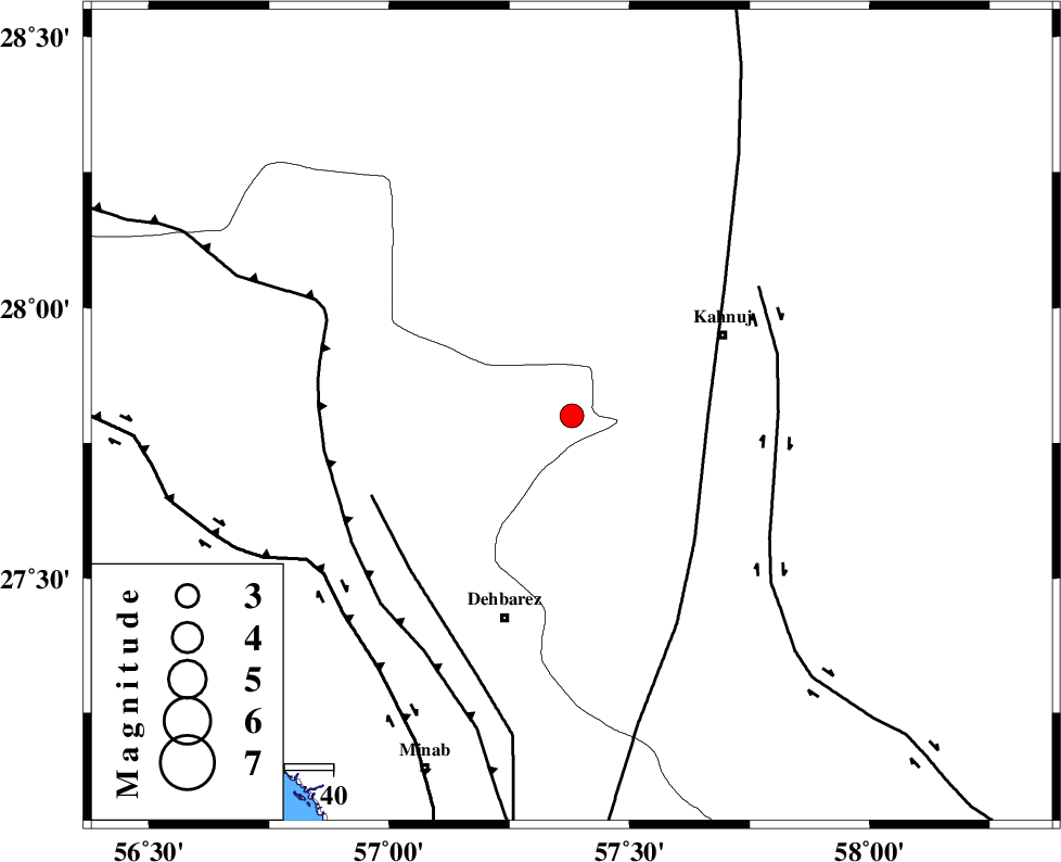
| Location | Lat:27.8 Lon: 57.38 |
| Region | Hormozgan Province, 35 km South-West of Kahnuj |
Nearest Cities |
|
| 10 km East of Fariab, Hormozgan Province | |
| 17 km North East of Ziaratali, Hormozgan Province | |
| 24 km North of Bejogan, Kerman Province | |
| 29 km North of Nodezh, Kerman Province | |
| 31 km South East of Faryab, Kerman Province | |
| Depth | 14 km |
| Agency | |
Faults within 150 km: |
|
| SABZEVARAN_F (Length: 190 km) , Distance to epicenter: 28 km | |
| JIROFT_F (Length: 144 km) , Distance to epicenter: 42 km | |
| ZENDAN_MINAB_F_Z1 (Length: 183 km) , Distance to epicenter: 44 km | |
| Number of Phases | 4 |
| RMS | 0 |
| Number of Stations | 3 |
| Error in Latitude | >1.6 km |
| Error in Longitude | 3.9 km |
| Error in Depth | 6 km |
Download waveform in seisan format
to download seisan software Click here
to access information about IIEES stations Click here
Amplitude | ||||||||
| UID | Agency | Station | Component | Amplitude | Period | Arrival Time | Proccessing Time | Signal Clip |
| 84345 | IIEES | BNDS | E | 338.6 | 0.4 | 2012-07-01 23:47:55 | 2012-07-02 02:55:00 | n |
| 84346 | IIEES | BNDS | N | 399.2 | 0.44 | 2012-07-01 23:47:55 | 2012-07-02 02:55:00 | n |
| 84347 | IIEES | KRBR | N | 127.9 | 0.32 | 2012-07-01 23:48:30 | 2012-07-02 02:55:00 | n |
| 84348 | IIEES | KRBR | E | 106.8 | 0.28 | 2012-07-01 23:48:30 | 2012-07-02 02:55:00 | n |
Phase | ||||||||||||
| Agency | Station | Component | Phase Type | Phase Quality | First Motion | Observed Arrival Time | Time Residual | Loc. Flag | Input Weight | Distance | Azimuth | |
| IIEES | BNDS | Z | Pg | E | 2012-07-01 23:47:37 | -0.01 | y | 127 | 250 | |||
| IIEES | KRBR | Z | Pn | E | 2012-07-01 23:47:55 | 0.04 | y | 250 | 346 | |||
| IIEES | KRBR | N | Sg | E | 2012-07-01 23:48:27 | -0.01 | y | 250 | 346 | |||
| IIEES | ZHSF | Z | Pn | E | 2012-07-01 23:48:12 | -0.03 | y | 388 | 58 | |||